|
The Writer's Home Range
Walks at RIT
by
I was slow to realize how close RIT is to the old Genesee Valley Canal. Of course, I had long known generally about the canals existence. On one of Terrys earliest visits to Rochester we explored the stretch through Genesee Valley Park west of the river, and on several occasions weve enjoyed hiking the stretch along the eastern edge of the gorge at Letchworth.
But like an interstate driver who loses sight of a car approaching him from behind, an intellectual has blind spots. The general idea of getting passed by another car is one thing. Catching sight of a distant car in your rearview mirror might even serve to make that idea a bit more concrete. Even so, its all too easy to forget about the approaching vehicle—until you find yourself immersed in the heart-thumping experience of nearly getting hit as you pull into the passing lane without looking.
So too when I finally opened a folder for my Black Creek material, I got surprised by the Genesee Valley Canal. One of the items in the new folder was a cover article from the weekly City newspaper. Although offering an overview, what the article featured was a canoe trip the author had taken along the stretch where the creek joins the Genesee.
I knew about the confluence from my drives to the U of R. From RIT, I usually take Jefferson Road west. Before crossing the river on Ballantyne bridge, however, I turn right (north) onto East River Road. Almost immediately, the mouth of Black Creek comes into view on the other side of the river (where the creek is crossed by Scottsville Road):
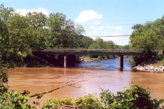
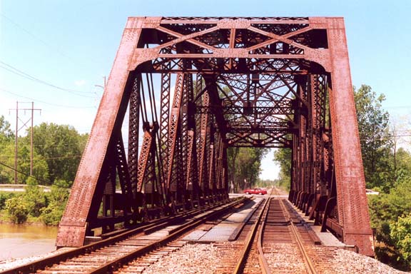
East River Road then rises to the level of the CSX railbed—the route of the old West Shore—which immediately crosses the river on a bridge of rusty metal:
Going back to the article, although I had a general understanding of the authors canoe route, his specific observations caught me off guard. To begin with, I learned that access to the creeks lower end wasnt restricted to canoes:
You can also walk or bike to one of the most gorgeous, secluded spots on Black Creek.
That seeming contradiction has been solved by the Genesee Valley Greenway, an emerging hiking-biking (no motor vehicles, please) trail which is resuscitating the route and spirit of the 19th-century Genesee Valley Canal.
The Greenway Friends recently beat a path northward from Ballantyne Road to the place where the Genesee Valley Canal used to span the quasi-bayou. You can leave your car at roadside and walk the 2,000 feet to this site in practically no time.
But what astonished me was a later remark:
Along the path, youll be greeted not only by nature in profusion, but by
some interesting architecture: the double-arch stone aqueduct . . . which
is overgrown as if to imitate Mayan or South Asian ruins.1
Not long after coming to Rochester, I had made a special trip to explore the aqueduct that once carried the Erie Canal across the Genesee downtown, and the old stone structure is something I often make a point of showing to out-of-town visitors. Could it be, I now thought to myself, that so close to my place of work theres a similar structure?
Had I given serious thought to the idea that a canal once stretched from the
Erie Canal at Rochester to the Allegheny River at Olean, I probably would have
realized that something of interest was likely to exist near the mouth of Black
Creek. After all, on my trips to Letchworth I had seen the pylons near Portageville
that once carried the canal (and later the railroad) across the Genesee. But
it never occurred to me that something special might still be standing, a scant
crow-flying mile or so from my office on campus.
In short, I had been beeped at, and in response I lost no time in taking a closer look. Specifically, in early June 2002—twenty years after interviewing for the RIT job—I went to explore, and Terry came too.
From our neighborhood, the most direct route was Hylan to Jefferson. Unlike my drives to the U of R, however, we didnt turn onto East River Road. Instead, we kept going—crossing not just the river but also Scottsville Road—by which time, Jefferson had become Ballantyne. Sure enough, ahead of us we could see a slight rise, where the highway crosses the railbed for the line that once followed the old canal route. Now it too was abandoned. But at the crest we found a small parking area and the newly installed gates for the hiking trail.
We then walked the route described in the article. The path itself followed the old railbed and (presumably) the old canal towpath. To our left lay a shallow depression: the remains of the canal. To our right, down the embankment, were grassy backyards—which, further along, gave way to swampy woods and then to open slackwater.
Finally, when the creek itself came into view, I scrambled down to the waters edge—and found myself looking at a relic of the nineteenth century:
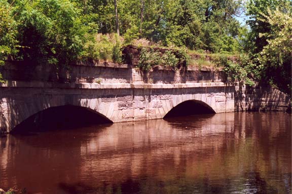
Like the aqueduct downtown, it was made of cut stone. But it was draped in late-spring greenery, and its arches were more low slung—though not so low as to impede the kayakers we later saw.
In mid-March the following year, Terry and I returned. Where we had made our previous trip at the time that spring was giving way to summer, we now found ourselves at the transition from winter to spring. The ground was still snow covered, but the day wasnt bitterly cold. Just north of the creek were the West Shore tracks, and the open area they created offered us good views of low-flying planes approaching the airport from the south. But even more interesting was a high-flying skein of Canada geese—about two hundred birds, by Terrys estimate.
Later in the day we drove to a section of the Greenway further south, this time hiking to a well-preserved lock. On the hike itself, I was also aware of the old railbed, and in the woods at regular intervals we could see the poles for the telegraph wires that once paralleled the tracks. As the woods gave way to open areas, our attention was again drawn to planes approaching the airport—considerably higher now, because we were further south.
Meanwhile, my thoughts kept returning to the geese—because they reminded me of a passage in A
Sand County Almanac. The book opened with a series of essays organized around the almanac idea. But instead of astronomical events, the passage of time was here marked by events involving wildlife. The March section, for example, featured an essay on Canada geese. One swallow does not make a summer, Leopold noted, but one skein of geese, cleaving the murk of a March thaw, is the spring.2
The high quality of the books writing—along with its short length—makes it ideal for classroom use. But the book is valuable for other reasons as well. Too often environmental debates are so highly polarized that participants talk past one another. Of course, Leopold himself had polemical moments—especially regarding the need to preserve at least some tracts of land from modern development. For example, in an essay about efforts to drain a marsh where cranes flourished he wrote:
The cranes were hard put, their numbers shrinking with the remnants of unburned meadow. For them, the song of the power shovel came near being an elegy. The high priests of progress knew nothing of cranes, and cared less. What is a species more or less among engineers?3
Fortunately, however, Leopolds voice is richly complex. Although the above
passage is quite critical, on other occasions hes
poetic and almost spiritual. Even his love of nature is complex. At various
times, the values he ascribes to wilderness are aesthetic, cultural, ethical,
scientific, and historical. Nor does he deny the importance of economic or
technological progress. But hes genuinely—and deeply—grief stricken
by the destruction of natural habitats that could, with a just little forethought
and effort, be preserved.
Despite such complexities, however, its clear that Leopold delights in direct, personal contact with nature. While he admits that this can be accomplished on horseback or in a canoe, the book most often finds him afoot. Thus, in one of my favorite essays he tells about getting up just before sunrise for a farm walk. At that time of day, he and his dog arent restricted by the boundaries recorded in the county clerks office. Expanses unknown to deed or map are known to every dawn, he wrote, and solitude, supposed no longer to exist in my county, extends on every hand as far as the dew can reach.4 Under such circumstances, the wildness that still adheres to the land is readily apparent. Finally, however, a neighbor will crank up his tractor or turn on his radio. At that point, the boundaries recorded in the county clerks office all snap back into place.
Although Ive often considered following Leopolds example, I havent been willing to get up as early as he did. But after reading his book so many times, I decided I wanted to try my hand at something like his approach. Oddly enough, the particular tract of land I chose was the RIT campus. Despite having a western border that basically follows the Genesee, the place where I work doesnt have the feel of a river campus. In large part, thats because East River Road acts as a buffer. But theres something else—something
that has become clear to me on my campus walks.
I usually arrive after the first classes of the day have begun, by which time
the lots closest to the buildings are filled. Some drivers will follow pedestrians,
in hopes they are returning to their cars. But because I have no patience with
this practice of vulching, I head straight for the far corner of the farthest
lot and have done with it. Another advantage of my habit is that when I return
to my car after a full day of teaching, I dont have to puzzle out where Ive
parked—because
I always park in the same place.
The best thing about my habit, however, is that it gives me an opportunity to walk. The stretch from my car across the lower lot is completely flat. Were this not asphalt, it would likely be wetlands. But once I cross the access road, I begin a gradual ascent. Thus the upper lot is terraced—with each successive double row of cars being at a slightly higher level.
Finally, I come to the buildings—and the end of my usual walk. But if I were to continue, Id play out the same sequence in reverse—with a twist. The buildings along the southern edge of campus (the student center, the library, and the science building) are all split-level. Each has its northern entrance at one level and its southern entrance at the next level down.
In other words, RIT is built atop a slight hill. But where the rise from the northern lots takes several hundred yards, the decline to the southern lots takes several hundred feet. Perhaps the asymmetry reflects some feature of the underlying bedrock. More likely, the hill was formed by the last advance of the Ice-Age glacier—though its overall contours dont fit the classic features of a drumlin.
While narrow in a north-south sense, the campus high ground is more extended in an east-west sense—with the distance west of the library being greater than the distance east. In fact, if you follow the high ground west, youre almost to the river before descending. There, on the downward slope, you find the one remaining structure that predates the construction of the campus:
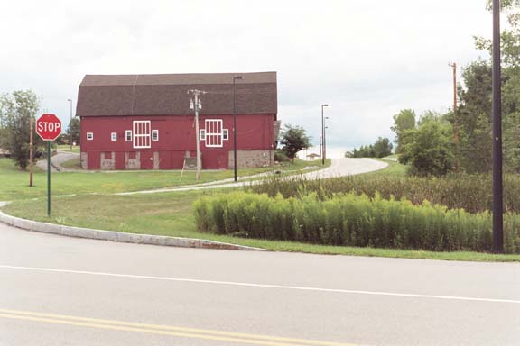
Its the Red Barn, now used for indoor rope climbing but once part of a farm (one of several) whose lands RIT appropriated in the 1960s.
Other than that, the campus is the product of a twentieth-century industrial aesthetic that includes not just the design of its brick buildings but also the choice of its flora. The contours may be those given by nature, but the surfaces have all felt the edge of mechanized steel blades—from bulldozers and backhoes to tractor-pulled lawn mowers. Plus the grass, the flowering plants, the bushes, and even the trees are all nursery bought.
Each year, just before commencement, the grounds are dressed. Grass is reseeded where snow plows accidently scraped to bare earth. Large pots of flowers are placed outside the doors of the library and in other locations. And everywhere you look, you see tents of various sizes—for musicians, for refreshments, for receptions, etc. The degree-presenting ceremonies may be held indoors, but the real celebrating is done out-of-doors, with the buildings serving as backdrops.
At such times, the environmental sweep of RITs development would seem to be complete. Yet in low-lying areas around the base of the high ground you can still see the wetlands that flank a small stream. Beginning south of campus, the West Branch of Red Creek flows eastward—away from the river—and then skirts the edge of the campus until its able to head northward.
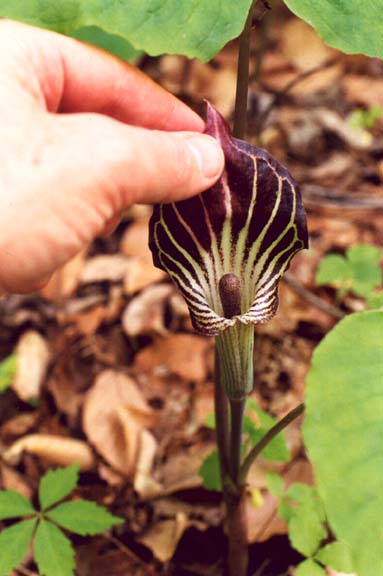
Truth be told, then, the RIT campus isnt really a creature of the river. Instead, its a creature of that small stream. Although the high ground has been extensively developed, the wetlands havent been completely obliterated. Indeed, there remains even now a gem of nature in RITs high-technology crown. By policy, a swatch of wooded wetlands continues to exist in something like its natural condition. True, a parking lot has been jammed right up against its western edge, and throughout its interior, a trail system has been laid out. But here each spring I can watch the succession of wildflowers coming into bloom—trout lilies, white trillium, mayapples, and others.
If I happen to be teaching the course in which I assign Leopolds book, I make a point of ending class early and inviting the students to join me for a walk. As we head east from the liberal arts building toward the student center, the terrain drops, allowing me to remark that despite extensive development over the years, the underlying topography of the campus is still natural.
After walking between the gym and student center, the terrain again drops.
But the level of the walkway remains constant—so that the Quarter Mile,
which connects the academic buildings to the residence halls, is actually an
embankment. Its also the northern edge of a forested swamp. Thus the asphalt
path we take to the south drops down to the flood plain. Finally we approach
the line of demarcation where—by policy—the
industrial aesthetic ends and the natural aesthetic begins:
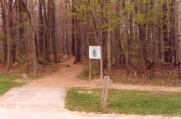
The first leg of the wooded trail parallels the Quarter Mile, and as we approach
the residence halls, we usually find ourselves laved in the sounds of recorded
music. At other times and seasons, however, the trail is quieter. On such occasions,
I might startle a snake, a heron, or a deer—or observe the V of a muskrats
wake on the pond.
 |
|
At the outset of this essay, I described how surprised
I was to learn about the existence of a nineteenth-century canal aqueduct
just a five-minute drive from campus. By contrast, Ive long known about
RITs wildflower trail. But maybe I should be more amazed by the continued
existence of any wetlands at RIT. After all, at a place that prides itself
in keeping up with new technology, isnt
it more remarkable that in the same time it would take me to walk from
my office to advanced labs in biotechnology or microengineering, I can—by
taking a different route—still
reach jack-in-the-pulpit blossoms?
|
Notes
1 Jack Bradigan Spula, Black Creek Is Beautiful, City, Vol. 28, No. 43 (for the week of 21-27 July 1999), p. 9.
2 Aldo Leopold, A Sand County Almanac and Sketches Here and There (Oxford University Press, 1949), p. 18 (in the essay The Geese Return).
3 Ibid., p. 100 (in the essay Marshland Elegy).
4 Ibid., p. 41 (in the essay Great Possessions).
|