|
The Writer's Home Range
Breakfast Walks
by
Back when I was living in my apartment on Crittenden Road, I learned that
short walks after waking made my morning writing sessions go more smoothly.
Twenty minutes of physical exercise also helped bring into better focus my
agenda for the rest of the day. Finally, if the outing included a stop at
the 7-11 on the corner of West Henrietta Road—to pick up a cup of coffee and something sweet (usually a package of Hostess cupcakes)—then
the whole experience became a pleasurable habit.
After my friend Terry and I moved to our house, in a subdivision just north of the Dome Center, I wanted to continue my morning routine. But the nearest 7-11 was located on the corner of East Henrietta and Lehigh Station Roads. Because that would have been more like a hike than a walk, I ended up driving.
What got me walking again was realizing that the A-Plus Mini Mart at the Sunoco Station on East Henrietta was much closer. More to the point, although I had long known that a paved walkway tied Colonnade Drive, near our house, directly to Suburban Shopping Plaza, I didnt resume my morning walks until I discovered that the line of trees along the plazas far parking lot also bordered the gas station and convenience store.
If the weather is nice—and Terry is already up—Ill leave the front door open for the cats. We keep them inside, but they like sitting at the base of the storm door—where they can keep an eye on the squirrels and the crows.
As I leave, I too survey the front yard. Does the grass need mowing? The flower beds, weeding? The yew bushes, trimming? The leaves, raking? The snow, shoveling? How about the two little trees from Tennessee? One summer we almost lost Tulip Poplar to drought, and another year we almost lost Sweet Gum when the neighbors cat began using the trunk as a scratching post. Both trees are now doing well, but I like to check.
I also keep an eye on the yard next door: holiday decorations that have just been put up, a newly-mulched flower bed, playthings left ouside, and so forth. Recently I was puzzled by a pair of large squares chalked onto the road in front of their house. But later Terry and I saw the kids using them to play a game with a large ball: “Two Squares” they called it.
After leaving Emerald Circle, I follow Colonnade to the left and then around a curve. In the process, I pass one of the handsomest redbud trees in the area:
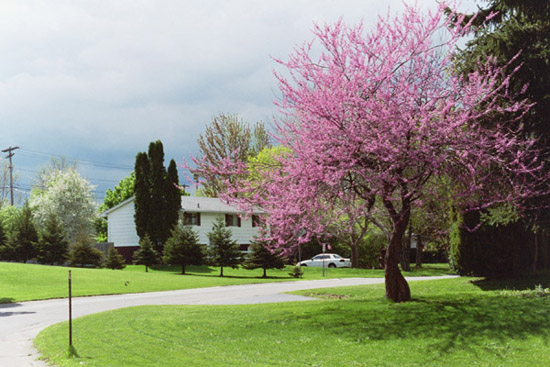
The owners effort to prune it several years ago took its toll, as did an ice storm during the spring of 2003. Yet its crown remains healthy, leading me to hope that its pink blossoms will continue their job of letting the whole neighborhood know the precise moment when spring becomes unstoppable.
A left turn puts me onto an asphalt path that heads eastward, up a gentle slope. To the right is a chain-link fence, which in summer is usually covered by a mixture of grape and poison-ivy vines. To the left is the mown grass of a greenway—part of the subdivisions drainage system, maintained by the Town of Henrietta.
As the path levels off, it turns sharply right and ends in the delivery area behind Bobs Restaurant—which anchors the plazas east-west line of stores. To get to the storefronts, I have to walk by the restaurants dumpsters, with their pungent smells and a vocal contingent of gulls.
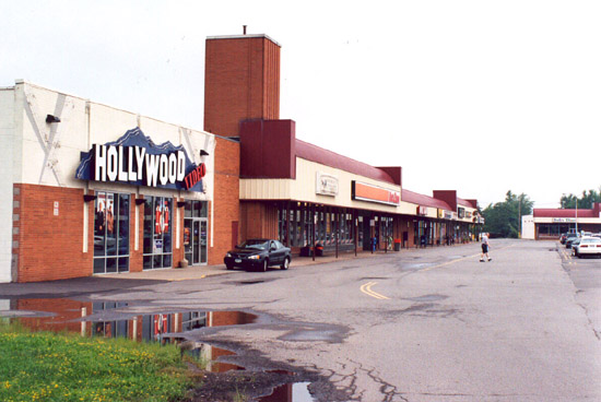
Next I walk the full length of the plazas north-south line of stores, starting with a liquor store and ending with Hollywood Video. And if I happen to see the older man who works at the dry cleaners, hes likely to greet me with a cheery “Good morning, Captain!”
Finally, I cross the far lot—which is usually empty, except perhaps for a van marked “Tooleys Oak & Amish Furniture” (the store next to Hollywood Video). By then, the dogs in their cages behind the animal hospital on East Henrietta have probably spotted me—setting off a cacophony of barking.
At the convenience store itself, I dont tend to do a lot of talking. After all, Im still waking up. Plus, my walks have become so habitual that I often get my coffee container filled, my cupcakes located, and my payment made without ever breaking my train of thought!
Perhaps if the clerk is new, he or she will comment on my well worn paper bag.
My reusable coffee container doesnt surprise them, though they might have to look up the standard price for refills. But they dont expect customers to provide their own bags—especially
one with so many folds and wrinkles.
On my return trip, Im more likely to notice the plaza as a whole—two strips arranged in an open-cornered “L,” bordering two sides of a huge parking lot:
The expanse is basically level. Yet the plaza is near the local divide. In particular, the walkway from our subdivision climbs upward to the plaza, while the terrain on the other side of East Henrietta Road slopes downward to the east. Thus water on our side drains to the Genesee, while water on the other side drains to Irondequoit Bay.
Usually Im on my own for these breakfast walks. But when my parents visited during the Summer of 2003, Dad and I followed a portion of my standard route. He didnt want to be gone long, and a round-trip to the plaza was the shortest distance I could think of that would take us “somewhere.”
Walks with my parents are a regular feature of their visits. The previous year, for example, we drove to the mouth of Irondequoit Bay and walked to the swing bridge and then partway along the pier. On another recent visit, we drove the short distance east on Calkins Road to Tinker Homestead, and after touring the nineteenth-century cobblestone farmhouse, we walked the grounds. Almost invariably, we also take neighborhood walks. But prior to the time that Dad and I went out together, he hadnt been to the shopping plaza. He had seen it, of course, but only from the road.
To keep the directions simple, we usually have out-of-town visitors exit I-390 onto East Henrietta. That way they reach our house by making a series of right turns: right, onto East Henrietta; right, onto Calkins, just past Wegmans (on the right); right, onto Beaconsfield, just past the Dome Center (on the left); right, onto Colonnade (when Beaconsfield ends); and right, onto Emerald Circle.
Although in following Colonnade they pass the walkway that leads up to the plaza, by then theyre more likely looking for Emerald Circle and our house. And even if they were to notice the walkway, the plazas proximity would seem implausible, given all the driving theyve done since passing it.
At any rate, when Dad and I reached the plaza, he was amazed by how close it was to our house. He also remarked that we seemed to be stepping back in time. For example, Weiders hardware store had a scale more in keeping with what I had known while growing up—in striking contrast to the vastness of a Lowes or a Home Depot today. I also pointed out the small barber shop where I had gone for haircuts after moving to Rochester, until the owner passed away (though the shop continues, under new management).
One “store” that doesnt really fit the standard pattern is the countys department of motor vehicles. And other stores are much more recent arrivals—with Hollywood Video being the best example. Basically, however, I agreed with Dads observation: despite changes over the years, the plaza retains the “feel” of the 1950s.
Subsequent research has verified the accuracy of that impression. Our house was probably built in 1964, and from newspaper clippings in the files of the public library downtown I learned that the very first house in our subdivision wasnt occupied until the latter part of 1961.[1] But Suburban Shopping Plaza opened in 1958, and the year before—when its construction was announced—a newspaper article[2] included an aerial photo with the plazas proposed boundary drawn in:
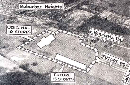
Note that the houses of a different subdivision—to the northeast, on the other side of East Henrietta—are clearly visible. Begun in 1954, Suburban Heights was one of Henriettas first subdivisions, a clear illustration of how Rochester was participating in the nationwide trend toward automobile-based suburbs.
Despite its being so extensively shaped by the conventions of postwar suburbia, however, the terrain of my morning walks also bears traces of earlier development. For example, no matter where we dig in our yard, we turn up fragments of clay pigeons:

A neighbor once told me that the immediate area had been part of the firing range for a gun club. Sure enough, when I began consulting directories for suburban Rochester, I learned that the gun club had as its address 2145 East Henrietta Road, just north of Suburban Plaza (at 2199). [3]
Plus a photocopy of a 1935 USGS topo map in the local history collection at the Henrietta Public Library explicitly showed a “Community Gun Club” at the end of a drive extending a short distance due west from East Henrietta. [4]
Further evidence of the pre-World War II past appears not far from the convenience store where I get my breakfast. If I happen to look across East Henrietta, I see an obvious reminder of the towns early years as a farming community:
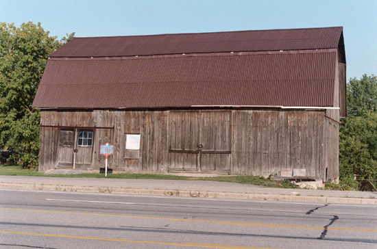
Although I dont know when the barn was originally built, the historical marker in front identifies the site as the “Richardson Farm,” which took its name from a “former underground railroad station owner.”
When I first began my breakfast walks, I was somewhat aware of the terrain I
was covering, But usually my thoughts followed other lines—such as trying
to decide which writing project to work on, once I was back home. Meanwhile,
in one of the courses I teach at RIT, I was regularly assigning a book that
(among other things) explored the extraordinary qualities of otherwise ordinary
land. Although A Sand County Almanac contained Aldo Leopolds classic
plea for wilderness preservation, it also brought the readers attention to
the wildness that continues to adhere to developed terrain. As Leopold himself
noted: “The weeds in a city lot convey the same lesson as the redwoods;
the farmer may see in his cow-pasture what may not be vouchsafed to the scientist
adventuring in the South Seas.”[5]
This theme was emphasized in the books opening section. Instead of discussing existing remnants of true wilderness, Leopold used the early essays to detail the natural features of the worn-out farm he had purchased as a weekend retreat for his family. Consider, for example, the behavior of a rabbit his dog once startled. Without hesitation, the rabbit made straight for a distant woodpile—which, Leopold reasoned, wouldnt have been possible had the rabbit not already known the lay of the land.
Long after I resumed my habit of taking breakfast walks, I was reminded of Leopolds story when I saw a rabbit ahead of me—in the grass of the greenway, just before the asphalt path made its sharp right turn toward the plaza. But all the rabbit did, in response to my approach, was to scamper to the base of a nearby tree. “Fat lot I can deduce from that,” I thought to myself.
Later, however, a more fruitful idea came to me. Leopolds main point about the rabbit was that it had a territory with which it was intimately familiar. In Leopolds experience, the same was true of other animals. But the extent of that familiar territory varied from species to species. Hence his interest in pursuing a series of questions. How far from their beds do deer forage? How far from their nests do grouse fly for berries? How do such habitual distances change with the seasons? To answer such questions was to establish what Leopold referred to as the species “Home Range.”[6]
Although I have an interest in natural history, Im not a naturalist. Instead, my new idea was based on a more figurative reading of Leopolds text. Like the rabbit of the essay, as a writer I too have a Home Range. Whats more, my Home Range isnt something Ive examined closely in any of my previous essays—because Ive developed my identity as a writer on more distant terrain.
I began by writing about New Yorks Southern Tier, where my grandmother lived. I then continued, with several series of essays that kept me “on the road”: exploring, across Pennsylvania and into New York, the route of the Sullivan Expedition during the American Revolution; exploring, from Lake Ontario south to the Pennsylvania border, the full length of the Genesee River; and exploring the high ground from which Rochester can be seen in the distance.
But when Im not taking such trips, what is the ground I cover? What are the
characteristic features of the terrain I move across every day? In short, what
is the writers Home Range? That is what I propose exploring in this series.
Each essay will examine some aspect of my immediate surroundings, and in each
Ill also continue drawing on Leopolds book, as a touchstone.
Notes
[1] John Street, “First Family Moves Into Wedgewood Park,” Times
Union, 1 Nov. 1961.
[2] Schuyler Townson, “Shopping Center Construction Set,” Times
Union, 24 May 1957.
[3] “Polk’s Henrietta,” p. 4, in Polk’s Rochester Suburban
Directory, Vol. 30 (R. L. Polk, 1959).
[4] Map No. 974.7895/U58m/1935, “Mendon Ponds, NY.”
[5] Aldo Leopold, A Sand County Almanac and Sketches Here and There (Oxford
University Press, 1949), p. 174 (in the essay “Conservation Esthetic”).
[6] The essay by this title (pp. 78-81) opens the “December” portion
of the book’s “Part I: A Sand Country Almanac.”
Illustrations supplied by the author
|