|
The Beddoe Tract
7,000 Acres in Central Western New York
Its History - from 1792 to 2004
by
The intention of this article is to put together pieces of
fragmented history about the Beddoe tract. In addition, it is appropriate
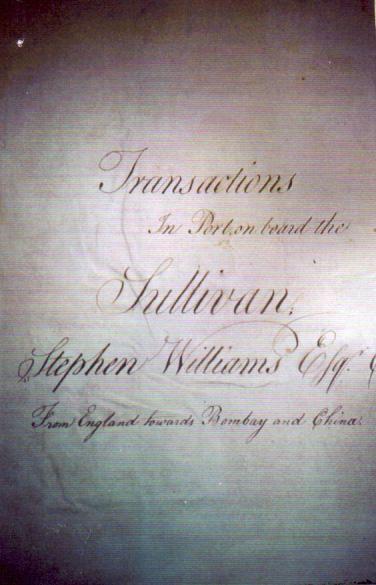
to include parts of John Beddoe's ship's log for the ship SULIVAN
on a voyage to Canton, China, from Portsmouth, England, during 1783, 1784
and 1785. This log was given to the Town of Jerusalem by Lewis Slingerland,
who inherited it from his grandmother, Adaline French. She lived near
the present Jerusalem Town Offices, then the District 14 Schoolhouse.
The log had been used as a scrapbook. Much time and care was required
to restore it to a readable form. Working with his log helped to reveal
Beddoe's background and the preciseness he followed in his work.
The smell of gunsmoke had hardly cleared from the
battlefields of the Revolutionary War before European investors began
to consider buying and selling real estate in North America as a money-making
possibility for them. Even earlier, shortly after the outbreak of the
war, Sir William Johnstone-Pulteney, member of the British Parliament,
had published a pamphlet titled: "Thoughts on the Present State of Affairs
with America, and the Means of Conciliation." He understood the stand
of the American Colonies on "taxation without representation" and urged
the continuing union of Great Britain and its American Colonies. Sir William
had sought as a British emissary under the name of "Mr. Williams," a conference
in 1778 with Benjamin Franklin in Paris, on this very subject.
Sir William Johnstone-Pulteney was, at this time, 49 years of age. Born
in Westerkirk Parish, Dumfriesshire, Scotland, at the family's ancestral
home of Westerhall, he was the third son of Sir James Johnstone and Barbara
Murray of Elibank. He studied law and in 1751 became a member of the Scottish
Bar and was respected in his field. He had a reputation of being a modest,
thrifty, refined person with good judgment. Johnstone carried out projects
for the public good in his home district and in Edinburgh. At age 31 he
had married Frances Pulteney, niece and heiress of the first Earl of Bath,
and daughter of General Daniel Pulteney. In 1767 she inherited great wealth
from her family. William Johnstone, following a British custom that the
husband of an heiress often assumed the surname of his wife in order to
administer her business affairs, took the Pulteney name.
Sir William had left Edinburgh for London in 1760, and served in Parliament
from 1768 to 1805. He was much respected by other members for his honesty
and integrity. His quiet manner and his strong personality was reflected
in the thoroughness with which he approached his duties in the House.
William Johnstone was a speculator in the development of real estate
in Bath, England, and even before the American Revolution he had investments
in the colonies and the West Indies. Johnstone inherited his wife's fortune
when she died in 1782 and had that wealth also to invest. A new nation
that had just achieved its independence was attractive not only to immigrants
but to speculators as well. He was not alone in recognizing the profit
opportunities in purchasing and opening up land for settlement; Dutch
interest ran high as well, with a like goal in mind.
There were some serious stumbling blocks to any investor's progress:
overlapping territorial claims of Massachusetts and New York, the original
rights of the Indian inhabitants, a lack of accurate surveys, and American
distrust of foreign investment. The two states convened the Hartford Convention
in November of 1786 in Connecticut to tackle their conflicting territorial
claims and the pre-emptive rights of land ownership within the region
between Lake Ontario and Pennsylvania. The appointed commissioners reached
an agreement before the end of that year.
Massachusetts was to get the pre-emptive rights and after the land was
sold; New York would receive sovereignty. The eastern boundary was to
be a north-south line extending north from the 82nd milestone on the Pennsylvania-New
York border to Lake Ontario. That meant the line would run, roughly, along
Seneca Lake's west shoreline. But, an actual surveyor's team had to traverse
the forested territory to establish the exact line. That turned out to
be a troublesome task.
For many years there was controversy over the survey and re-survey of
this eastern boundary. Oliver Phelps, Nathaniel Gorham and other New England
investors purchased about two million, six hundred thousand acres of central
and western New York State from Massachusetts under the condition that
they fairly acquire the ownership right from the Indians—the Massachusetts
State legislators insisted that Indian rights be settled by a treaty.
The fairness of these arrangements, which concluded July 8th, 1788, have
been controversial to this day, but a treaty was made which secured the
title for Phelps and Gorham.
A land office was opened in Canandaigua, but really serious financial
troubles dogged the steps of these investors. In about two years Phelps
and Gorham were forced to return large tracts of unsold land to Massachusetts.
That state, in turn, resold these lands to an American, Robert Morris,
known as "the financier of the American Revolution," in November of 1790.
Now, events began to accelerate for the investors over-seas. In London,
William Temple Franklin, grandson of Benjamin Franklin, an agent for Robert
Morris, sold just over a million acres of land to the Pulteney Associates
in 1792. The partners in the Associates were Sir William Pulteney with
a 9/12th interest; William Hornby with a 2/12th interest and Patrick Colquhoun
a 1/12th interest. This tract became known as the Genesee Tract as it
ran from the Pre-emption Line to the Genesee River on the west between
Lake Ontario and the New York - Pennsylvania border.
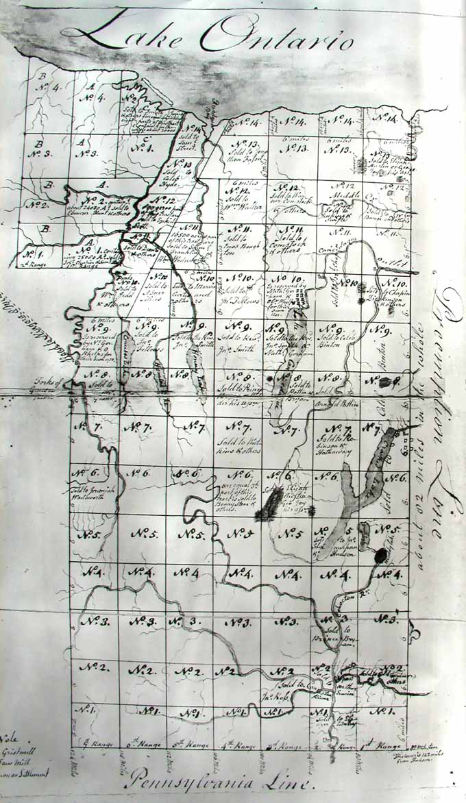
1790s map of the Genesee Tract
showing sales and reservations made by Phelps and Gorham.
Courtesy of the Steuben County Historical Society.
Now, Sir William Johnstone-Pulteney had a purchase,
but at that date, aliens were not allowed to hold title to land within
the new nation. Another adventuresome Scotsman, Charles Williamson, was
hired to administer the associates land in America. To do so he became
a naturalized citizen and had the property in his name, held in secret
trust for the British investors. Williamson left his wife and young family
in Pennsylvania while he scouted the new territory. This was an awesome
job; only Indian trails criss-crossed the wilderness at this time. While
Seneca Lake and Crooked (Keuka) Lake were navigable, no large rivers gave
easy access to them. In 1792 he explored the approximate route used by
Sullivan's Campaign from the 1779 incursion into this area, to quell Indian
massacres such as the one in Cherry Valley in New York, and in the Wyoming
Valley in Pennsylvania.
Coming north from Northumberland, Pennsylvania, up the Lycoming to the
Tioga and Conhocton Rivers, Williamson encountered rigorous traveling
conditions. He went as far north as the Big Tree (Geneseo) area.
After returning to Philadelphia, he went around to the other approach
route, up the Hudson and Mohawk and Wood's Creek through another trying
journey over to Seneca Lake and Crooked Lake. It was there, near Savona,
that he fell ill with Genesee Fever. The bout left him with malaria-like
symptoms of the mosquito-borne illness. He was cared for by the John Dolson
family until he could recuperate enough to continue his tireless pursuit
of his land agent job. Williamson possessed the energy and dedication
to personally oversee projects at Williamsburg (named for Sir William
Pulteney) just south of present Geneseo, Bath and Geneva as well as Sodus
and Lyons and Hopeton (just west of present Dresden) all at the same time.
* * *
A great religious fervor seemed to develop in the
newly established United States. From Rhode Island came a new sect, established
by the first native-born American woman to organize a large group of followers
with sufficient finances to seek new lands for a colony. This was Jemima
Wilkinson, who called herself the "Publick Universal Friend." The group's
land scouts came into this area in 1787 and chose land on the west shore
of Seneca Lake near where the outlet of Crooked Lake flowed into Seneca
Lake. The scouting party reported back to the society, some of whose members
were still in Rhode Island and Connecticut, and others in eastern Pennsylvania.
The Friend Society decided to make their settlement here by Seneca Lake.
Twenty-five came and wintered here in 1788-89. It was a brutal and hazard-filled
experience for them. They had managed to clear land and plant 12 acres
of wheat using a harrow to break the ground. Wild game supplemented their
food supply. Rude log houses sheltered them. The "Genesee Fever" invaded
their ranks. Their outpost was at first called the "Friend's Settlement,"
but soon became "New Jerusalem." By 1790 the census showed 260 people
inhabiting the community. The Friend herself joined them in the spring
of that year. A mill for grinding grain was set up on the outlet and a
suitable house built for their leader.
The followers of The Friend were industrious and hard working. They built
log houses and a log meeting house and a grist mill; the crop land and
nearly level land lying near large Seneca Lake seemed good. She had nearly
three hundred followers surrounding her "City Hill" settlement. Trouble
came in the "clouded" land title to portions of the earliest cleared land.
The Universal Friend's agent, James Parker, had tried for bargain-priced
land from a group called the "Lessees." Unfortunately, the title was deemed
null and void by New York State due to an unfair "leasing" deal the Lessees
had made with the Indians.
By back-breaking work, land had been cleared, houses had been built so
several of the Friends lost their investment. The bulk of the settlement
was on land with good title from Phelps and Gorham, but Parker had been
sure he was buying three or four thousand acres from, the "Lessees." Final
settlement on his purchase yielded only 1,100 acres, so some Friends lost
much of their money and labor, with little or nothing to show for it.
Then, the survey of the Pre-emption line made in 1788 was found to be
in error and a new survey was made in 1792.
The deeds were on the basis of the first survey and the line veered
from its start at the Pennsylvania line to the northwest and at the Lake
Ontario end, near Sodus, it made a difference of several miles. The area
between the Pre-emption survey line of 1788 made by Col. Maxwell and the
re-survey of 1792 made by Benjamin Ellicott was called The Gore, a long,
triangular shaped piece of land containing 85,896 acres. The second survey
was accepted as the legal Pre-emption Line by the State of New York.
The confusion of losing title to property crossed by "The Gore" and the
earlier Parker-Lessee experience caused great stress in the Friend's colony.
The Universal Friend herself, became very upset over the clamor caused
by these "Title" problems. Charles Williamson, by this time, was the administrator
of the surrounding unsold property. An adjustment was worked out whereby,
those who had lost land in the "Gore" would be able to obtain three acres
for every one acre lost in the "Gore" survey mistake.
The Friend was uncomfortable with the atmosphere of uncertainty created
by the title disputes. She hoped to withdraw to "where no intruding foot
would enter." In 1794 she moved about twelve miles to the west of the
original settlement. She had a temporary house built on the bank of the
inlet on the north end of Crooked Lake. This stream had been named Brook
Kedron by a member of the Universal Friends, Thomas Hathaway, who, along
with Benedict Robinson, had purchased the land in the so called "second
seventh." The followers who came to the new location, and the Friends
household made maple sugar each spring from the sap of trees along the
stream which later lost its biblical reference and became known as Sugar
Creek.
The Friends held meetings on Saturday (their Sabbath) at the new log
house. Jemima Wilkinson returned at regular intervals to hold meetings
at the log meeting house at the City Hill location along Lake Seneca.
Sometimes they met at David Wagener's house situated on the site of present
Penn Yan.
The Friend was not only a spiritual leader to her followers, but she
also gave advice, settled minor disputes, consoled them at the loss of
members of the flock, conducted their funerals and was skillful at treating
their illnesses and injuries. Neighbors were well treated and the Indians
regarded her as a good friend to them. Whenever groups of Indians came
by, she, or members of her household, gave them food, and the Indians
brought her deer meat or fish.
Travelers enjoyed the hospitality of the Friend, and even those hostile
to her religion gave praise to her even-handed treatment of others around
her.
Her temporary house in Jerusalem was enlarged several times before her
permanent home was ready for occupancy. Situated on the hill to the west
about a half mile from the "Brook Kedron" house, the sturdy, beautiful,
New England style home has been restored by the present owners and stands
today (2004) as a private dwelling.
Jemima Wilkinson’s home in Jerusalem, Yates County, New
York
Construction began in 1809 and was completed in 1815.
The house was beautifully restored in the 1950s and 60s by Joseph and
Rena Florance.
This 1908 photograph was supplied by Betty Smalley of Dresden.
All other pictures following were supplied by Jane P. Davis
She moved to her new house in 1814. In her later years, she became a
victim of a slow and painful illness and rode in a coach fashioned for
her on the under-carriage of the one she had owned in Pennsylvania. She
kept active and continued to preach. The Friend was carried to the funeral
of her sister, Patience Wilkinson Potter, on April 19, 1819, and preached
her final public sermon. Jemima Wilkinson "left time" on July 1st that
same year.
Back in the 1790's The Friend's followers, T. Hathaway and B. Robinson,
had been offered land in the Geneseo area as well as the Jerusalem site.
Because The Friend objected to separating her flock far from the original
settlement, the Geneseo area land was refused. After The Friend had moved
in 1794 to her temporary home by Brook Kedron, Hathaway and Robinson found
they would be unable to pay for the whole of Jerusalem township. James
Wadsworth, who had purchased the Geneseo area land which Hathaway and
Robinson had refused, was already dealing in land in the western part
of the state and went to England in 1796-97 on business. He sold this
7,000-acre plot in Jerusalem to a Scot, John Johnston.
Identifying which Johnstone or Johnston this person was, is a bit confusing
because branches of the family frequently spelled their last name with
or without the "e." According to Orsamus Turner's publication of 1851
titled History of the Settlement of the Phelps and Gorham Purchase
and Morris Reserve, a John Johnstone came in 1791 from Scotland to
America with Charles Williamson. Indeed, he was Williamson's "right hand
man" in developing the earliest settlements of Williamsburg and Bath and
Geneva, etc. In the late 1790s John served as a land agent for the Hornby
and Colquhoun interests (part of the London Associates investor). He visited
his native land from 1797 to 1799; This is how he was on hand to buy 7000
acres from James Wadsworth. He then sold them to John Beddoe, whose brother-in-law
was Charles Johnstone, a first cousin of Sir William Johnstone-Pulteney.
Networking worked—even in the1790s! A temporary deed was issued
in 1798. Spelling of the grantor's name was Johnston in the body of the
indenture and in the signatures of John Johnston and Ann Johnston.
John Johnston and Ann Johnston transferred 600 acres in 1798 to John
Beddoe of Esperanza. A second deed to Beddoe, dated 16th of August, 1802,
processed in Ontario County, NY., was for the entire 7,000 acres. It seems
transfers from Wadsworth and the Morris family were not completed in 1798
but the legal work was cleaned up by 1802. The name is spelled Johnston
on this deed as well. E. Thayles Emmons in his 1931 publication of
The Story of Geneva states that "The house on the west side of Main
Street at the corner of St. Clair Street
is reminiscent of the early activities
of Cap't Charles Williamson, inasmuch as the original house on the lot
was occupied by John Johnston, assistant to Cap't Williamson, and who
served as accountant and office man." Evidently he dropped the "e" as
he served as land agent in Geneva, Ontario County, New York. (Emmons p.
413) Emmons further mentions that Johnston, as he visited his homeland
in 1799, had persuaded John Greig to come to America. Greig succeeded
John Johnston upon his death in 1805, as agent for Hornby and Colquhoun
lands, and had bought the Johnston house.
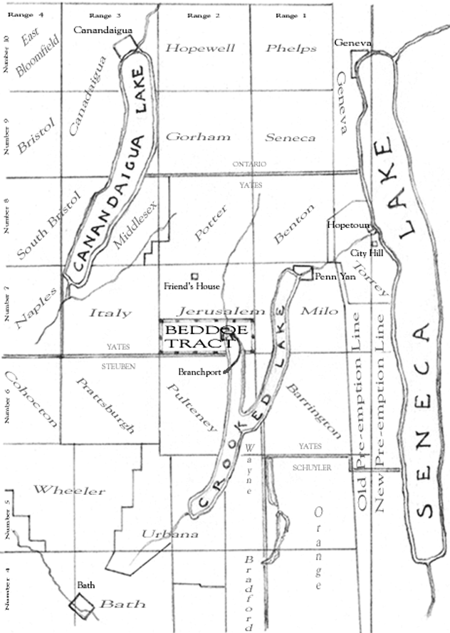
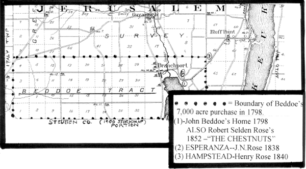
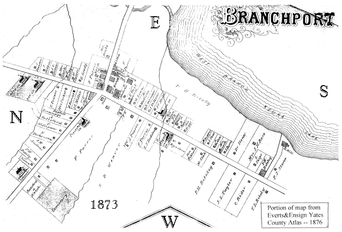
Map of eastern central area of the Genesee Tract showing the location
of the Beddoe Tract in the Town of Jerusalem in Yates County. The
Beddoe Tract was in the surveyed section designated as Number Seven
in the Second Range. The Village of Branchport at the head of the
left branch of Crooked Lake was in the Beddoe Tract. Map prepared
from an 1803 map. Historical sites and villages, Yates County and
present town names and boundaries added.
John Lynham Beddoe was born in Herford, Wales,
in 1763. He entered the British maritime service and like other 15-year-old
boys entering the service was sent off to work his way upward. The large
East India Company was owner of many of the British ships which went
to Africa, India, and China during the 1700's. In early December of
1782 Beddoe began the "In-Port Log" for the ship Sulivan. Since
this ship was named for Lawrence Sulivan, an official of the East India
Company in the 1760's, it must have been owned by the East India Company.
J. Beddoe refers to the company throughout his log as the Hon'ble Co.
(probably a shortening of Honorable, and much easier than to write out
than the whole name). His "In-Port Log" is available, but the "High
Seas Log" is not. Some excerpts copied from the "High Seas Log" are
on record.
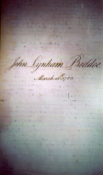
John Beddoe was 19 years of age at the beginning of this voyage. He
kept both the "In-Port Log" and "High Seas Log" but did not list himself
in the long list of officers and seamen. Commander Stephen Williams
was in charge. Perhaps at this age Beddoe was acting as a servant to
the Captain. The Log begins in Deptford during the loading of "Pig"
iron for ballast, water and food for the voyage, various cargo items,
and then readying the ship throughout. Daily records were kept of how
various workers and seamen were employed, as well as stores of materials
for the boatswain and gunner stores. Each day the wind and the weather
conditions were recorded. If mooring, water depths were recorded and
any cargo loaded or unloaded was noted.
In about a month's time, the ship moved to Gravesend. There sails were
hauled out and cables readied for use. These operations took from December
5th, 1782, to March 4th, 1783. They then went to Portsmouth for more
preparations and sailed for China the 15th of March, 1783, around Africa
to Bombay to unload cargo and recruits by September 20th. This was the
Sulivan's first voyage. It was a 876 ton vessel, built in England
by Barnard.
The ship and crew appear to have spent from the 20th of September,
1783, to April 16th, 1784, making short trips up and down the west coast
of India. Beddoe logged repeated entries naming Bombay, Tellicherry,
Cochin, and Mangalore, where business was carried on for the British
Military, the Hon'ble Company, and some private parties. Very careful
records were made of other ships at anchor, or anchoring nearby, or
sailing, and their destination, if known. Recorded also were ship's
stores and food and water brought aboard for the crew. Gun salutes were
the "cell phones" of the day, and much gun powder must have been spent
firing salutes as new arrivals anchored or departed. Also, visiting
dignitaries were accorded the same loud honor when they visited an anchored
ship.
Beddoe carefully noted punishments to disorderly crew members or any
deaths from illness or injury. Mentioned also, were ships wrecked by
storms and the fate of the crew members who were endangered. Ship's
crews were aware that warring factions on sea or shore brought the threat
of hostile fire. This was frequently encountered in the Malacca Roads
area between the Indian Ocean and the Pacific. Indeed, the log recorded
delays in that area on this voyage. The Sulivan reached Whampoa
[also spelled "Wampoe, in this log] by July 8th, 1784. The voyage from
Tellicherry, India, had taken over two months, due partially to the
Dutch military restrictions in the Malacca Straits, where they were
struggling to keep control of the area.
The bay at Whampoa was 10 miles down river from Canton. This was the
only access port the Chinese allowed foreign trading ships to use. China's
military control was strict and officials called "hoppos" came and measured
each ship upon its arrival and demanded hefty payments from each ship's
Captain before any trade could take place. Long boats took cargo being
sold up to the "hongs" which were the trading warehouses, just on the
edge of the City of Canton. All tea, silks, dishes (china) and other
merchandise bought from the Chinese merchants, was brought back down
river in those long boats and loaded onto the ships anchored in Whampoa
Bay.
Trouble came when the Captain of an English ship, The Lady Hughes,
ordered his gunner to fire a salute as an important visitor left after
visiting the Captain. A Chinese fisherman was accidentally killed by
this tribute. The authorities had demanded the gunner, but could not
find him. Late in November the Chinese authorities seized the Supercargo
of The Lady Hughes as hostage, because of the death of the
Chinese fisherman. "The Canton War" was the name given this unfortunate
incident which became a story in itself, brief, but of international
importance.
America's first trading ship to go to China, named The Empress of
China anchored there Saturday, August 28, 1784. On board as Supercargo,
(the ship's business agent), was Samuel Shaw, representing the first USA
businessmen willing to risk sending a cargo for trade with China. Shaw
was well received by the Chinese, but he objected to both the penalty
for the hapless gunner and the taking of a hostage by the Chinese, even
though in doing so, he risked a punitive reaction from the authorities
and perhaps loss of his trading rights and his sponsor's cargo.
Shaw enlisted the help of the agents of the other ships anchored at
Whampoa, who were to meet with the Chinese rulers up river at Canton,
regarding this incident. Shaw proposed they all withhold any more trading
of cargo until the Chinese recognized the unfairness of the death decree.
During the meeting, they stood together, until a valuable bribe of two
bolts of exquisite silk to each ship's representative was proffered
by the Chinese official "in friendship." Then, they caved in. The fate
of the gunner was sealed. Shaw took his "gift" and turned it in to Congress
and John Jay, foreign affairs official, under the Articles of Confederation,
with his protest of the unfair conduct of the Chinese officials. His
cargo was sold at a good profit, and a cargo of tea purchased for his
sponsors. Shaw was named first American Consul to Canton by the Confederation
Congress in 1786.
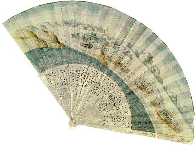
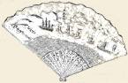
Fan given to Samuel Shaw, super-cargo on THE EMPRESS OF
CHINA, the first United States ship to trade with China, as a memento
of the 1784 "Canton War" episode. SULIVAN was anchored nearby.
The EMPRESS is the ship to the far left, identifiable by the
US flag.
Beddoe had no knowledge of these details, he recorded in his log "Tuesday,
September 7, 1784; Anchored here the Lady Hughes, Capt'n Williams from
Bombay
." (this was in the Bay at Whampoa), (later as ship Sulivan
was getting ready to depart and at the 2nd bar, in Canton River) "Sunday,
November 28
the ship Commodore brought an account that the ships at
Whampoa, manned and armed their boats and sent them to Canton to obtain
release of the Supercargo of the Lady Hughes, who was carried into the
city, a prisoner." "Monday. November 29, 1784,
employed clearing the
ship for sea, and for action, in case of an attack from the Chinese."
"Wednesday, December l, 1784. At 2 PM the cutter returned from Canton,
having the quartermaster that had steered her, wounded in the breast,
in forcing her way up to the city. By her we learnt that the supercargo
of the Lady Hughes was released, the Captain of her having delivered
his gunner to the Chinese
." "Wednesday, December 8, 1784 - "
P.M. Came
down, and anchored, the Lady Hughes."; Thursday, December 9, 1784 -
"
A.M. sailed the Lady Hughes for Bombay:.". Thus, the new owner of
7,000 acres of NYS District of Jerusalem, was a "world traveler before
he set foot on his new tract in America! Almost certainly, he was the
only Jerusalem resident in 1798, who could have claimed the distinction
of having been on three continents of the world.
John Beddoe had named his new real estate in New York, Esperanza. This
is known for certain because he brought with him a younger cousin named
David Morse. David Morse had been brought up by an uncle, John Evans,
of Wales. Evans thought the young man had a chance of making his fortune
in the "new world" of America, and a letter to him read, "I was very
glad to hear of your safe arrival at Esperanza. I understand you all
had hard work of it from New York thither
." Indeed, traveling to the
"Genesee Country" in 1798 was difficult. The account of Beddoe, his
young wife and David Morse and their travels, comes from several different
sources. They arrived in New York from England in the middle of May
of 1798. They took a sloop bound for Albany, a two-day trip, and went
by land to Schenectady, where they purchased a three-ton boat. It had
a "carriage assembly" which could be used in areas where portage was
necessary.
They made their way, using the Mohawk River, Wood Creek, Oneida Lake,
Oneida River, Cross Lake, Seneca River and Seneca Lake, Crooked Lake
Outlet to Crooked Lake, with some tough portage spots in between bodies
of water and around falls. Likely, teams of oxen were used to pull Beddoe's
conveyance on the "dry" spots. The travel on Wood Creek is described
in diaries of travelers in the 1790's as very tedious. On reaching Oneida
Lake the travelers found hazards: "
the lake is extremely turbulent
and dangerous
bateaumen commonly hug the north shore as safest
." From
all accounts, Evan's remark in a letter to his nephew "
you had hard
work of it from New York, thither
" only skimmed the surface of the
great hardships endured by the Beddoe party in reaching their new home
on the shores of Crooked Lake, in June.
Beddoe had hired James Sherratt, a carpenter in New York City, to come
with the party to build a dwelling and farm buildings. Local lore has
it, that he was called James Sherwood in this area. The Beddoe family
homesite was located where Keuka Lake State Park is now. Stories published
in the area newspapers over the years, do not all agree on the exact
spot; there were three dwellings. Fragments of those accounts here indicate
that Mrs. Catharine Beddoe stayed in Geneva for a brief time while her
husband and James Sherratt (Sherwood) and five men hired in Geneva came
to the Esperanza homesite and built a small frame dwelling. Mrs. Beddoe
came to live in this home. Their first child, Johnstone Beddoe, was
born there in 1804, and daughter, Charlotte in 1805.
The five man crew evidently went right at land clearing. Beddoe had
40 acres of winter wheat in the ground in the fall of 1798. This is
documented in one of a series of letters written by Charles Williamson
and published in The Documentary History of New York, Vol. 2,
edited by E. B. O'Callaghan in Albany, NY; in 1849; p. 1158.
Recollections of some of Jerusalem Township's pioneers relate that
in a few years Beddoe's homesite had the look of an English country
estate. These same pioneers observed with good humor that Beddoe's life
at sea had not readied him to be an agriculturist! Remembering that
his previous hay crop had "heated" and spoiled in the barn, (due to
its not being dry enough to store), Beddoe was exasperated at the difficulty
he was having with the succeeding hay crop. He is said to have raged,
"I cut that hay in the rain, piled it up in the rain, and drew it to
the barn in the rain, and it will burn itself up in spite of the devil!"
His farmer neighbors had a good laugh, but not in his presence.
Beddoe's second house, built in 1807 of hewed logs was larger than
the framed house built by Sherratt. The site of this one is a bit vague
in writings about the family, but it seems to have been a short way
north of the first dwelling. This structure was built by Benjamin Durham.
Henry Barnes, whose family came to Jerusalem in 1794 with Jemima Wilkinson,
recalled that as a lad, he and his brother Julius helped to cut the
notches to fit the ends of the logs at the corner joints. He said the
logs were so carefully squared that they required no chinking, and that
the finished building was a handsome one.
By this date another son, Lynham, arrived in 1807. He completed the
family. It must have been a very rugged existence for Mrs. Catharine
Beddoe, since medical facilities did not exist here yet. She died at
age 35 at her home in 1815. She left a son of 11 years, a daughter of
10 years, and another son of 8 years. What a sad turn of events for
a pioneer family!
Some accounts indicate a third dwelling, a framed house, had been built
a bit farther back from the lake than the log dwelling. It stood near
the J. N. Rose farmhouse, and was still standing in 1872. Written details
on this dwelling seem elusive. It is recorded that John Nicholas Rose,
son of Robert Selden Rose and Jane Lawson Rose, bought 1,058 acres from
John Beddoe in 1824. This Rose family had come from Virginia to the
Geneva area in 1804. John was the second son of this prosperous family.
After graduating from Union College in Schenectady, his ambition was
to own farm land at the north end of the west branch of Crooked Lake
in Jerusalem Township of the "new" Yates County. This county had been
"set-off" from the large Ontario County in the year in 1823.
* * *
It is appropriate to insert here the situation
between Sir William Johnstone-Pulteney and his land agent, Charles Williamson.
By 1800 Pulteney was upset that he was not getting more and faster returns
on his investment. Since he never personally viewed his purchase of
the Genesee Country, a complete wilderness, without connecting navigable
waterways or trails wide enough for wagons, it is understandable that,
because over a period of eight years funds had gone out rapidly and
come back to him very slowly, he would reason that his investments were
poorly managed. His strict habits of thrift imposed on himself, in his
youth, were coming to the fore.
Pulteney decided to appoint Robert Troup to be his Land Agent in 1801
which meant that Charles Williamson would no longer be in the top command
spot. This was not acceptable to Williamson. Small wonder that Williamson
chose to "walk". Lockwood Doty in his Genesee Country, published
in 1925 cited Samuel McCormack's memoir which said, "
Charles Williamson
discharged his difficult duty in a manner which will not only be the
source of incalculable advantage to the future proprietors, but to secure
to him the lasting gratitude of that part of America which formed the
theater of his meritorious exertions. He is styled with much propriety
the Father of the Western Part of the State of New York."
To promote the sale of land, Charles Williamson had held "world fairs"
in Williamsburg and Bath, complete with horse racing and entertainments,
which attracted well-to-do men who bought land and spread the fame of
the Genesee Country. He had roads built between settlements, hotels
and sawmills erected, and he had successfully helped thwart Canada's
Governor Simcoe's plan to interrupt establishment of the village of
Sodus and to seize a buffer zone along the south shore of Lake Ontario.
Williamson had written pamphlets promoting the region and cited successful
settlers who had bought land and established homes and farms. All of
this seemed to be insufficient in Sir William's eyes. Pulteney had a
reputation for privacy, scrupulous honesty and integrity and very frugal
living habits; Williamson was an outgoing, exuberant optimist—not
surprisingly, their personalities clashed.
Attorney Robert Troup began his work when Charles Williamson resigned
the duties of his Land Agent job in 1801. After long negotiations, settlement
was made with Sir William Pulteney in 1805. Williamson was to have White
Hart Farms, (the south end of Bluff Point) as part of the agreement.
Until 1815 that portion of Bluff Point was still a part of Steuben County.
He also received Springfield close to Lake Salubria near Bath. In all,
Williamson received over 13,000 acres in the two parcels, and a small
payment of cash—his reward for fourteen years of hard work. Perhaps,
the London Associates thought the land would have sold in large parcels,
bought by wealthy speculators who paid at once for their purchases.
Instead, the pioneer farmers and businessmen were the buyers and needed
to use their land to make money. Mortgages had to be arranged to do
this. Clearing the land took time, improving roads and canals for access
to markets took time, thus, payments came in slowly and disappointed
the Associates.
Williamson returned to Scotland and entered government service. He
died in 1808 of yellow fever while returning to England from government
business in Havana, Cuba, and was buried at sea. A son and daughter
had died as young children. Alexander, in Northumberland, Pennsylvania,
in 1793; Christy in Bath from fever the same year. A daughter and a
son, Charles A., went back to Scotland when their father returned in
1808. This son later married a Miss Clark and lived in Geneva, N.Y.
He died in Ft. Laramie from cholera in 1818, while searching for gold.
The rainbow's end did not seem to contain rewards for the Williamson
family.
Sir William Pulteney had died three years previous to this in 1805
at age 75, his estate came to his only daughter, Henrietta Laura, Countess
of Bath. She had married Sir James Murray, a cousin. She died at age
41 in 1811, and left no descendants. The Pulteney estate was administered
through a succession of agents for the relatives. By 1904 much of the
Pulteney Estate had been sold. The remainder was sold to Nichols and
Wynkoop of Bath. Their representative sold the last deed to that remainder
in 1926. The great American land speculation of Sir William Pulteney
did not appear to be rewarding to him or his immediate family, but he
certainly made history. In his obituary published in Gentlemen's
Magazine it was stated, "
he was penurious only to himself."
John Johnstone, Williamson's right hand man, became land agent for
the Hornby and Colquhoun portion of the London Associates in the Land
Office in Geneva, N.Y. He, too, died in this same decade, in 1806, He
was succeeded by John Greig, a young Scotsman he had persuaded to come
to America while Johnstone was on a visit to Scotland in the late 1700's.
Greig became a bank president, a Representative to Congress from Ontario
and Livingston Counties, and Vice Chancellor of the New York State Board
of Regents. He was held in high esteem by his associates.
* * *
Meanwhile, John Beddoe was perfecting his first
"homestead" at the north end of Crooked Lake's west branch. His farming
skills were few, but he persisted for a time. The grounds were well
planned and looked like a bit of English countryside transplanted. David
Morse, the cousin who had accompanied the Beddoes to America, worked
for Captain Beddoe for several years, and by 1802 had written John Evans
in England that he was buying farmland just to the southeast of Captain
Beddoe's purchase. Eventually David Morse had a farm of about a 300
acres. His Uncle John seemed proud of him in letters written in reply
to David's news, especially that David's new farm was named, Trerose,
which was the name of the Morse holdings in Wales. David married Mary
Boyd, daughter of William and Esther Parkinson Boyd in August of 1804.
They prospered and farmed the Bluff Point farm and by 1820 had a family
of four sons and a daughter.
John Beddoe in 1812 sold 640 acres to a George Brown. This plot occupied
the area around the north end of the west branch of Crooked Lake and
the site of the little village of Branchport. However, George Brown
died comparatively young and the property reverted to John Beddoe.
Beddoe had the 5,000 acres of the western end of his purchase surveyed
by Jabez French into ½ mile square lots which he advertised for sale
in the Geneva Gazette in 1816. Many deeds to these properties,
even today, reference the location as, "Lot # ( __ ) of the Beddoe Tract."
After losing his wife in 1815, and selling over a thousand acres of
his original "set aside" acreage to John Nicholas Rose, John Beddoe
and his children moved, about 1825, to his "homestead westside" which
was directly across the west branch of Crooked Lake from his first homesite.
By this time his children's ages were 21, 20, and 18.
Johnstone Beddoe, the eldest, died in 1828 from epilepsy. Charlotte
Beddoe married, in 1828, George Stafford of Geneva. In 1829 they had
a son, John Beddoe Stafford, who grew up in the household of his Uncle
Lynham, after his parents died in the early 1830's.
John Beddoe continued to live on his "homestead westside" until 1829
when he sold part of this site to James and Rebecca Taylor. They lived
there until 1850 raising a large family in this location just south
of Basswood Creek.
Lynham Beddoe married in 1831, Eleanor Cuyler Cost of Oaks Corners,
New York. Lynham and Eleanor soon moved to the large house built by
George Brown only a few doors south of the four corners in Branchport.
That property had come back into John Beddoe's possession after Brown's
death in 1820. The couple had four children: Eleanor C., William C.
J., James C. and Mary Cammann. Only three of Captain Beddoe's grandchildren
were born before the Captain's death in 1835 at the home of his son
Lynham. (those would have been John Beddoe Stafford and the first two
of Lynham and Eleanor's children, James C. and Mary Cammann were born
later than 1835).
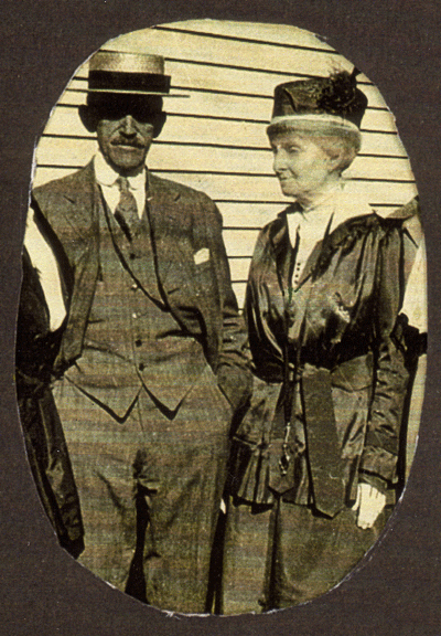
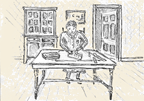
John Beddoe's granddaughter, Mary Cammann Beddoe Hurd,
and her husband, Duane Hurd in a 1920's photo. Both Hurds died
in the mid 1930's. She was the last surviving descendant of Captain
Beddoe.
John Beddoe served three terms as Town of Jerusalem Supervisor and
later on, Lynham, also, held that office. Lynham established a hardware
store on the northeast site at the four corners. He inherited the balance
of the unsold lots of the Beddoe Tract. By this time, lumber merchants
had chosen to buy large lots in this area. The opening of the Crooked
Lake Canal completed in 1833, alongside the outlet from Penn Yan to
Dresden, greatly stimulated their business. The canal allowed narrow
rafts of logs to be floated around the end of Bluff Point to Penn Yan
then into the canal and on to Seneca Lake, thence, to the Seneca Canal
and the Erie Canal to the Hudson River to the ship building industry
at Yonkers.
Two of Branchport's prominent citizens engaged in the timbering business.
They came about 1832, bought land on the Beddoe Tract, shipped away
the timber and sold the land for farming. Peter Bitley, on contract
with Nichols and Paddock, and later on his own, became prosperous from
shipping spar timbers by this water route. Solomon D. Weaver, also,
engaged in the same practice, with handsome financial reward.
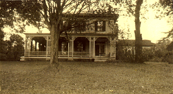
John Nicholas Rose, who had bought over a thousand acres from Captain
Beddoe, in 1824, established his farming operations and by 1838 had
completed the building of his handsome mansion. He chose a prime location
on a slope overlooking the west branch of Crooked Lake. He built a stone
mansion with Greek Revival architectural features. The four massive
stone pillars on the south-facing portico gave great dignity to the
structure, the largest single dwelling ever built in Yates County. The
view toward the lake—spectacular! Completed in 1838 and named
"Esperanza" it still stands today, one hundred and sixty-six years later,
but (as noted by Verne M. Marshall in his Roses of Geneva)
has had a rather checkered history of use.
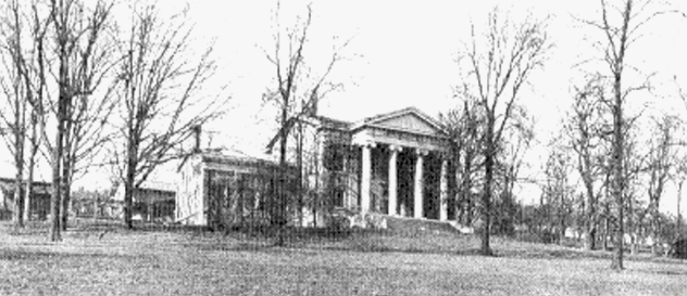
Esperanza
Built in 1838 by John Nicholas Rose of Branchport.
For more about the Roses and Esperanza, read “The Branchport Connection”
from The Roses of Geneva by Verne M. Marshall
reprinted in Issue 84, March, 1995, The Crooked Lake Review.
Included are first floor and second floor plans of the supposed original
room arrangements.
In 1873 George Snow had vineyards there and a grape juice company in
Penn Yan. His family also lived in the mansion. Wendell T. Bush and
family in 1903 used it as a dwelling, as did Clinton Struble in 1917.
Yates County bought the farm and dwelling in 1923 and made some additions
and remodeling to use it as a County Home for elderly and unfortunate
county residents who needed a place to live. By 1950 the County felt
the farm and upkeep of the buildings was impractical. Other accommodations
were sought for the residents and for many years the building stood
vacant. Serious vandalism took place during the next years. Another
party bought the property but did not actively farm or use it as a residence.
An art gallery was attempted by Mrs. Betty Ann Bader, in its next use.
She began some restoration in 1967 but her early death brought a close
to her project.
Then in 1979, a winery named Chateau Esperanza was established by the
Lombardi family. The basement area was used for wine production and
the tasting room was in the west wing. Little restoration was attempted.
In 1985 this winery operation was suspended. A real estate developer
proposed a series of townhouses on the farmland uphill from the mansion
and restoration of the mansion for a hotel, but sudden changes in real
estate values doomed that construction. Shay and Edwards purchased it
to develop a bed and breakfast and restaurant, but repairs and upkeep
prevented the completion of their plans.
In 2003, Esperanza received a multi-million dollar renovation in the
hands of new owners, David and Lisa Wegman. A full-service banquet facility
building has been added, a new restaurant within the mansion, as well
as nine suites for bed and breakfast accommodations. The grounds have
been newly landscaped. The meaning of "Esperanza"—hope—has
become visible, after a long interval.
John Nicholas Rose's brother, Henry, built his home "Hampstead" about
a mile east of his brother's Esperanza, but not on the Beddoe Tract.
It was completed about the same year. Henry Rose's mansion was smaller,
of wood construction, and in the Greek style. It also has stood the
test of time and still stands today, and is in use.
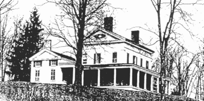
Hampstead
Built in 1840 by Henry Rose of Branchport.
For a description and history of the house, read Gloria Sill Tillman
in Issue 41, August,
1991, The Crooked Lake Review. Her grandfather was the nephew
of Henry Rose.
She was born in the house and lived there at the time she wrote the
article.
A drawn elevation and floor plan is included.
Shortly after John Nicholas Rose's death in 1870, his wife, Jane Macomb
Rose, moved to a small house a bit south of St. Luke's Episcopal Church
in nearby Branchport. The Rose families were instrumental in the building
and support of the beautiful stone church, built in 1866-1868. St. Luke's
has an active congregation and has been kept in excellent repair, with
some additions and modification.
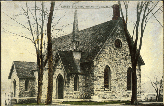
St. Luke's Episcopal Church completed in 1866
across the street from
the Lynham Beddoe residence in Branchport.
A nephew of the Rose's, having the same name as his grandfather, Robert
Selden Rose, also built a large home on land which had been part of
the Beddoe purchase. It was the site of the Beddoe's first residence.
R. S. Rose had bought from his Uncle John N., in 1853, about 360 acres
along the lakeshore. He built a large stone house there, not as grand
as his two uncles' mansions, but a fine dwelling. He had married Frances
T. Cammann of New York City. She was the daughter of a well-to-do banker
who may have helped the couple purchase their homesite on Keuka Lake.
They raised a family of seven children there. These children remained
in the area as adults. The only daughter, Catharine Navarre Macomb Rose,
devoted much of her life to activities related to St. Luke's Church.
Three of her brothers lived in Geneva and three lived at "the Chestnuts"
(as the R. Selden Rose place was called) or nearby. This beautiful house
was demolished to make room for the Keuka Lake State Park buildings
in the 1960's.
A nephew of John N. and Henry Rose, R. Selden Rose and his wife, Frances
Cammann Rose,
built "The Chestnuts" on the site of John Beddoe's first
home about 1850. It was demolished
in the 1960's to build the Keuka Lake State Park buildings.
So, at the start of the 21st Century, two of the three Rose structures
stand, but only one of the Beddoe's houses remains, the house built
before 1820 by George Brown in Branchport, in which Lynham and Eleanor
Beddoe had raised their family, and where Captain John Beddoe spent
the last two years of his life. The house in 1908 was cut into halves.
The south portion was to have been moved just 30 feet south across the
driveway and friends of the owner's at that time were to buy it. The
plans were altered and the south half is in use today as a dwelling
about a five hundred feet southward along the Main Street, but on the
opposite side facing west, beside the Branchport Library. The north
half still is on its original site, across from St. Luke's Episcopal
Church. It has been used as a dwelling almost continuously.
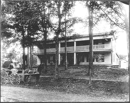
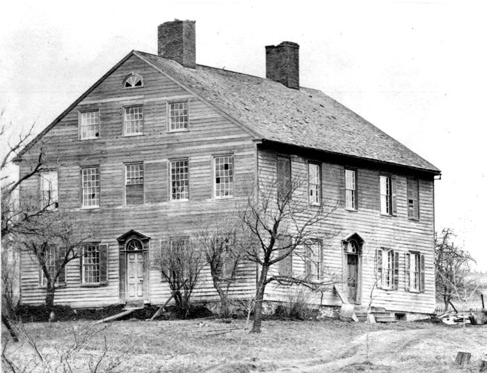
HOUSE BUILT AROUND 1812 - 1814 BY GEORGE BROWN
Brown had purchased 640 acres from John Beddoe. It was intended as a
tavern
but Brown died and the property reverted to the Beddoes. Lynham Beddoe,
son
of Captain John Beddoe, lived here with his wife and family in the 1830s.
John Beddoe died here in his son’s house in 1834.
The Beddoe Purchase on the early maps appears in two segments. One
part, about 2,000 acres near the end of the west branch of Crooked Lake
was not shown to be in surveyed lots. The other section of the purchase,
was the 5,000 acres (about two miles wide and four miles, east to west)
which Captain Beddoe had Jabez French survey into thirty-two plots of
160 acres each to be sold as farmland.
The settlement which became Branchport was slow to take root. George
Brown had bought, in 1812 from Beddoe, six-hundred and forty acres at
the north end of the west branch and around to the west side of the
lake. He built within a few years, a large two-story frame house, 60
feet long, intending it to be used as an inn and tavern. It was reputed
to be the first frame house in the village. He was not able to complete
his plans and died in 1820, before he had completely paid for his purchase,
which reverted to John Beddoe, since his widow, Sarah Potter Brown was
unable to pay off the debt. This was the house in which, later on, Lynham
Beddoe and wife Eleanor raised their family and their nephew, John Beddoe
Stafford.
The town grew slowly because the inlet to the
lake, Sugar Creek, offered no good place for fording such deep, and
in springtime, such swift water. It was difficult to build sturdy bridges
in that era, and the swampy terrain was not encouraging. The creek was
fordable 2 miles to the north, so the Stage Route ran from Penn Yan
to Larzelere's Tavern up West Hill to Italy Hill, then over to Prattsburg,
Wheeler and Bath, completely missing Branchport.
By 1831, Samuel S. Ellsworth and Spencer Booth built a store on the
southwest corner of the cross trails. Spencer Booth suggested the name
Branchport when a post office was to be established. A usable bridge
was soon fixed in place across the inlet stream.
The history of the settlement is well told in S. C. Cleveland's History
of Yates County, (1873) and in Miles Davis' History of Jerusalem,
(1912). Stimulated by the great demand for spars and timbers and farmers
hungry for land to farm, the little village had a population over 300
in mid 1800's. The blacksmiths, cabinet makers, coopers, wagon makers,
carpenters, and the operators of sawmills, harness shops, grist mills,
and basket factories—are all named in the books mentioned.
Beddoe Tract land began to be sold for farm land in 1825. Albert Cowing
is reputed to have been the first permanent settler on the 5,000 acres
that had been surveyed into lots by Jabez French. Cowing's parents and
their large family had come to the area west of Seneca Lake in 1803.
Settlers in Jerusalem had as their principal product pine shingles,
which became known as "Jerusalem Currency." Cowing and his wife, Sally
Torrance, established their holdings about a mile east of the Italy
Township border. Their "farm" was a dense wilderness of principally
pine and oak trees. To make pine shingles the settler needed an axe,
a cross-cut saw, a shaving knife and froe, and a rough bench called
a wood horse. The worker then cut the trunk of the felled tree into
16" or 17" segments. Taking a segment to his "wood-horse" bench, he
used the other tools to split and edge the shingles.
The new settlers had the strenuous job of clearing the land of the
stumps and roots to make way for the fields to raise wheat, oats, corn,
beans and hay. Hay was the "gasoline" of the day, for transportation
was by horse or ox-drawn vehicles. Up-turned stumps were the fences
to keep livestock in their pastures. The roots were made to interlock
so that the larger animals were fenced in. It would be hard to find
such a fence still in existence today. No road had been laid out from
Branchport to Italy Hill in the late 1820's, and farmers had to make
their own. When John Nutt in 1827 bought 160 acres about a mile west
of Branchport, he hired Simeon Cole to cut a road by his place to the
road to Pulteney.
Names of other very early buyers of lots on the Beddoe Tract were John
and William Runner, Ezra Loomis, Meli and Benajah Todd, Daniel Johnson,
Benjamin Rogers, and Seneca Badger. These names only skim the surface.
Surprisingly, most of these buyers moved here from the Starkey and Milo
area; they were not newly-arrived immigrants from England or Ireland.
Lumber merchant, Peter Bitley, shipped from 1833 to the mid-1860's
an average of 250,000 cubic feet of timber annually according to Fran
Dumas' excellent book A Good Country, A Pleasant Habitation.
That translates into two and a half million board feet a year! Much
of this was from the Beddoe Tract. From 1865 to after the turn of the
century, grape culture became a very important farm industry and the
hillsides along the valleys were suited to this use. A steamboat dock
at Branchport made shipping handy. Two brothers in the Stever family
set out some of those vineyards along the south border of the tract
by the Steuben County line.
A railroad was built in 1897 with warehouses at Kinney's Corners and
Branchport, which gave another shipping point for produce grown on this
tract.
View from Pinnacle (once called Rose Hill) looking west, circa.
1915, shows Branchport, and some of the farmlands sold from the
original Beddoe Tract. The Penn Yan, Keuka Park, Branchport Railroad
was functioning and warehouses at East side and near Sugar Creek
are visible. The steamboat dock at the south end of the village
is beyond the left side, but most of the "steamers" had
been retired by this date.
A survey on use of farmland early in the twenty-first century on the
land encompassed by the Beddoe Tract, would find that crop farming of
wheat, oats, rye, buckwheat, barley, corn, beans, is not profitable,
although some is grown. Dairying and livestock raising, as well, are
not found to flourish, although all of these farm activities were money
makers for the early settlers and those farmers who followed, until
about 1960. Whether world markets, improved transportation or government
agricultural policies, caused the change, is subject to debate. Grapes
continue to be grown, but not the table grapes or grapes for grape juice,
jellies, nor standard wines, which the earliest vineyardists found profitable.
Instead, currently, most vineyards are planted to hybrid vines. The
market is best for "European Type" varietal wines which these vines
produce. The change in New York State law to allow "Estate Wineries"
on individual farms; the rising popularity of wine consumption; coupled
with tourism promoted by regional Chambers of Commerce wine tasting
tours, has breathed new life into agriculture on the slopes of the Beddoe
Tract near Keuka Lake.
Much of the cropland, not devoted to vineyards, is being let go back
to brush and woods. Some has been reforested, some grows low quality
hay, cut and baled up to be used as mulch between vineyard rows. But
there is a rapidly growing "crop" on these beautiful slopes—dwellings!
Some are quite modest, some are large and impressive. They all share
the wonderful scenic vistas of hills and lake. Many are along the highways,
nearly as many are at the ends of long driveways in wooded sites along
small streams. John Beddoe, if his spirit were to come back today, would
not find English country estates, but people very happy to be in such
beautiful settings.
Perhaps, if human life-span had been 300 years instead of 77 years
for Sir William Johnstone-Pulteney, and he could have read the assessment
valuation of the real estate encompassed in his huge purchase in today's
terms, he might have seen that in the long haul, his real estate investment
was very sound. He might even have taken a more charitable view of Williamson's
approach to opening up the territory.
All is supposition, but The Beddoe Tract has not lost its charm or
beauty, and for today, if John Nicholas Rose and wife, Jane Macomb Rose,
could visit ESPERANZA, they would see it shine! Vacationers and campers
and local citizens can enjoy Keuka Lake State Park on the grounds of
Captain John Lynham Beddoe's homestead.
View of Branchport on Keuka Lake
Sources
It is harder, sometimes, to "sweep up" after a main event
than it was to prepare and participate. In designating sources, it's important
that contributing reservoirs of information do not miss getting mentioned.
The information furnished by Jeffrey M. Johnstone, in
his account of Sir William Johnstone-Pulteney and Charles Williamson,
was of prime importance to this endeavor. This background material was
part of the foundation on which the Beddoe Tract history rests. In addition,
Jeffrey's assurance that within the Johnstone genealogy (as in many other
families) the "e" may be used or dropped at the end of the surname by
different members of the same "clan". This encouraged me to pursue the
identity of the purchaser of the "Wadsworth" property and to discover
that it was the same John Johnstone who had accompanied Charles Williamson
to USA in 1791. He signed the deeds to John Beddoe's 1798 purchase, using
the "Johnston" spelling.
The works of Frances Dumas and of David Minor (Eagles
Byte) helped enormously with sequence and continuity. The historical
essay Steps West by John M. Robortella aided with an understanding
of the land surveys and the Pre-emption Line survey, along with copies
of primary documents.
Orsamus Turner's Pioneer History of Phelps & Gorham
Purchase, and E. Thayles Emmons's The Story of Geneva furnished
background on the Pulteney Estate and the land-office era of the story.
As always, when pursuing local historical events, S. C. Cleveland's History
of Yates County was very valuable. Herbert A. Wisbey, Jr.'s Pioneer
Prophetess filled in details of Jemima Wilkinson, the Publick Universal
Friend and her colony.
John Lynham Beddoe's "In-Port Log" on the EIC Sulivan
1783-1785 trip from England to China when he was just 19 and 20 years
of age, was an important source. From data received on the Internet from
Tony Fuller, who does marine research, it was possible to find data on
the ship, not only when it was built but, where, and its size, and additionally,
Captain Stephen Williams's full name and family background, and when he
retired from sea duty.
Robert W. Drexler wrote in April 1997 an article for
American History (magazine) entitled "The Canton War" which filled
in the background for Beddoe's short account of "the trouble with the
Lady Hughes," as he recorded it in his log.
Frances Dumas, Yates County Historian, was able to loan
me copies of letters to Beddoe and his cousin David Morse (one to John
Beddoe before he emigrated to the U. S. from Charles Johnstone dated 12/16/1797,
letters to David Morse from his uncle, John Evans, 1799 - 1805), as well
as copies of letters to a local newspaper by Henry Barnes, who helped
build the second John Beddoe house on his "purchase" beside Crooked Lake.
Verne M. Marshall of Geneva, NY, published in 1993, a
most interesting and informative book, The Roses of Geneva, which,
along with Cleveland's history, and The History of Jerusalem
by Miles Davis (1912), supplied local background material. From an unknown
newspaper of April 1870 was an account of the Beddoe Family and in another
paper a list of early settlers on the Beddoe Tract. Local newspaper articles
on the Beddoe family were also used: Flora Evans Vail's "Beddoe Family"
appeared in the Chronicle Express, Penn Yan, NY, in 1932; Frank
Swann mentions Mary Cammann Beddoe Hurd in a May 16, 1936, issue and articles
"Henry Rose House, Hampstead," (1952) and "John Beddoe" (1952) in the
Chronicle Express.
David Minor's series about the life of Charles Williamson,
"The Life of a Salesman" in the Crooked Lake Review, traced Williamson's
involvement in the Pulteney land purchase.
Copies of Deeds and Court Actions from the Yates County
Court House also substantiated the limits and dates of purchase for the
Beddoe Tract.
A letter to Sally Davis from Mrs. Mabel (Nathan) Oaks
in 1969 regarding Eleanor Cuyler Cost Beddoe provided information.
Maps were also helpful and included an 1824 map of the
Genesee Country, 1829 & 1840 maps by Burr, an 1865 map by Stone and Stewart,
and a Cyrus Wheelock 1876 map published by Everts & Ensign.
The pieces of the "jig-saw puzzle" have existed for some
time. Stories, both accurate and inaccurate, appeared in locally published
materials. The restoration of the Sulivan log brought the need
for this history to the fore. The Canton War piece by Robert W. Drexler
(American History, March 1997) also needed to be incorporated
into the background that was available on Captain John Beddoe and his
family. What courage it must have taken for this little family to persevere
on the frontier at that time, and what sorrow they had to endure. The
Township of Jerusalem is indeed fortunate that some of the early-built
structures still survive: Lynham Beddoe's dwelling, and the two Rose mansions,
Esperanza and Hampstead. Maybe "HOPE" was an accurate name for Beddoe's
venture.
Broken grave marker for John Beddoe
lying in the
Beddoe-Rose Cemetery in Keuka Lake State Park
References
Brooks, Charles E., Frontier Settlement, Holland
Purchase, Cornell Univ. Press, 1996.
Cleveland, S. C., History of Yates County,
2 vol., Chronicle office, Penn Yan, NY 1873.
Davis, Miles A., History of Jerusalem, Penn
Yan, NY, 1912.
Doty, Lockwood R., History of the Genesee Country,
Charles Pub. Co., Chicago, 1924.
Dumas, Frances, A Good Country, A Pleasant Habitation,
NYSARC, Penn Yan, NY, 1990.
Dumas, Frances and S. Coneybeare, Cemeteries of
Yates County, 1996.
Emmons, E. Thayles, "The Story of Geneva," Geneva
Daily Times, Geneva, NY, 1931.
Gardner, Brian, The East India Company, Barnes
& Noble, NYC, 1971.
Hedrick, U. P., History of Agriculture - New York
State, New York Agriculture Society, 1933.
Jemison, B. P. and Anna Schlein, Treaty of Canandaigua,
1794, Clear Light Pub., Santa Fe, 2000.
Johnstone, Jeffrey M.," Sir
William Johnstone Pulteney," Crooked Lake Review,
Issue #132, 2004.
Marshall, Verne M., The Roses of Geneva, Windswept
Press, Interlaken, NY, 1993.
New York State Canals, Edition of 1952, U.S.
Lake Survey, Detroit MI, 1952.
Robortella, John M., Steps West: The Field Notes
of Col. Hugh Maxwell (1733-1799). " Summary"
appeared in The Crooked Lake Review, Spring 2004.
Rose, Christina L., "Esperanza," House Beautiful
Magazine, Vol. XL. #2, 1916.
Smith, Warren Hunting, "The Chestnuts," The
Crooked Lake Review, pp. 8 - 9, Issue 28, July, 1990.
Turner, Orsamus, Pioneer History of Phelps and
Gorham Purchase, Alling, 1851.
"When West Met East—Picture Portfulio," American
Heritage, pp. 9 - 25, August 1972.
White, Marion Churchill, Centennial and Ten: A
History of St. Luke's Parish, Tillman, Penn Yan, 1966.
Willis Clarence, The Pulteney Land Title: Genesee
Tract, 5th Ed., Advocate Press, 1924.
Wisbey, Herbert A., Jr., Pioneer Prophetess, Publick
Universal Friend, Cornell Univ. 1924.
[Articles in the CLR: "Hampstead,"
by Gloria S. Tillman, includes sketch and floor plan, Issue 41, August,
1991; "Recollections of Jemima Wilkinson, [The friend."]'The Friend,'
as Related in 1890 by Mrs. Huldah Barnes Davis and an explanation by Herbert
A. Wisbey, Jr.," Issue 55, October 1992; "The Branchport Connection,"
from The Roses of Geneva by Verne M. Marshall, Issues 79 and
84; Esperanza floor plans of supposed original arrangement, Issue 84,
March, 1995.]
|