|
|
| Home | Index | Museums | Blog | Authors | Site Map | About |
|
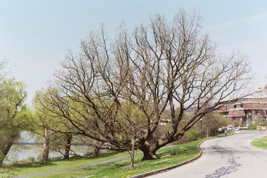
The Writer's Home RangeThe Barge Canal TrailbyThomas D. CornellOther Essays in the Writer's Home Range SeriesFrom the outside, the Rustic Village Apartments on Crittenden Road in Brighton—where I lived from 1982 to 1992—all look alike. Once while Mom and my sister-in-law Linda were visiting, they returned to what they thought was my building and knocked on what they thought was my door. When someone else opened it, they were at first completely sure that he was in the wrong place! Thats how much alike the buildings look. The houses in the neighborhood where Terry and I now live arent similar to quite that extent, though many do have similar features—both inside and out. I mention this, because a high degree of sameness has been one of the main criticisms leveled against suburbia. I do agree that how we live helps shape how we think. But I dont find the alleged conformity of the suburbs to be as threatening as some would have it. To begin with, my experience is that literal sameness tends to fade with time. For example, one of our neighbors on the circle originally had their basement stairs arranged in the same configuration as ours—at the entryway from the garage into the kitchen. But then they decided to move their basement stairs to the front entryway. Other neighbors enclosed their back porch and added a shed along the side of their garage. Even more dramatically, following a house fire several years ago our neighbors across the greenway rebuilt the damaged section with two stories rather than one. And so the differences accumulate. Sheer familiarity also figures into my comfort level, because suburban neighborhoods are where Ive lived most of my life: in Austin, Texas; Dayton, Ohio; Stillwater, Oklahoma; Starkville, Mississippi; and now Rochester. Despite their different locations, all these suburbs illustrated the same national trend. After the war, developers began mass producing housing in much the same way that manufacturers prior to the war had mass produced automobiles—by standardizing the design and building many at one time. Just as the new manufacturing techniques made car ownership possible for people who couldnt otherwise have afforded it, so the new building techniques opened up home ownership. The result was a dramatic population shift. For more than two decades after World War II, about the same number of people moved to the new suburbs annually as had come to the U. S. annually during the peak years of immigration just after 1900.1 Because of my history studies, however, I also know that theres an even larger pattern at work here. The rise of automobile-based suburbs after World War II was actually just one stage in a century-long social experiment. Instead of keeping wealth concentrated in the hands of a relatively small elite, the U. S. as it industrialized created a broad middle class, with considerable political, economic, and cultural autonomy. For precisely that reason, however, there remains a challenge: will a society dominated by a broad and powerful middle class succeed at advancing civilization in a way that commands future admiration and emulation? Because the rise of the middle class is such a collective, multi-generational trend, particular individuals cant really be held responsible. Nevertheless, as a child of postwar suburbs, still living in their environs, I feel an obligation to add my bit. What Id like to explore in this essay are some of the earlier stages in the rise of Rochesters middle class. Put another way, my daily travels put me onto terrain shaped by pre-World War II suburban developments. To begin with, where RITs current campus reflects the postwar era, the River Campus of the University of Rochester—which was built from scratch in the 1930s—reflects the interwar years. And still other aspects of my trips to the U of R libraries reflected developments before World War I. When I first began going to the campus, Id park as close to the main library as I could. After Wilson Boulevard was closed, however, the parking arrangements were changed. To avoid the uncertainties of metered parking, I began leaving my car in Genesee Valley Park, at a spot near the Barge Canal. Yes, that did require a walk. But it was a pleasant one, taking me past mature tulip poplars and stately oaks—including one of the finest-looking white oaks in Rochester: |
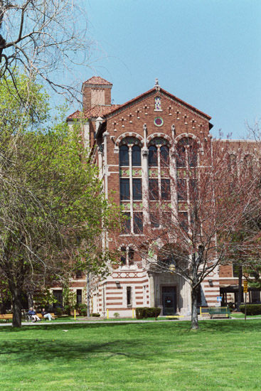 |
In any case, however, the hospital was the first notable feature along that stretch of the trail. Perhaps because Im accustomed to seeing, at RIT, multi-storied brick buildings with almost no adornment, I was excited by how wonderfully decorative the hospital is—with its white columns and accents, carved stone features, and even touches of color in places. The hospital is also distinctive in being the creation of Rochesters first Black architect. When Siegmund Firestone, the buildings architect of record, interviewed Thomas W. Boyde, Jr., Firestone is reported to have said: I was not aware that you were a Negro. To this, the story continues, Boyde immediately replied: You advertised for an architect. You didnt ask for the color of my skin.2 The hospitals south side today faces the suburban communities of Brighton and Henrietta. At the time it opened, in 1933, what it actually faced was the Barge Canal. Now, however, theres very little boat traffic on the canal. The towpath trail—which we joined from the hospital parking lot, via a side trail—is quite popular. But its traffic pales in comparison to the number of vehicles whizzing along the canals southern edge. |
Having I-390—and its sounds—so near, prompted me to recall a passage from A Sand County Almanac. What Terry and I usually seek in our hikes is something different from our regular routine. Similarly, Leopold noted: Recreation is valuable in proportion to the intensity of its experiences, and to the degree to which it . . . contrasts with workaday life.3
The saving grace of this stretch of the canal trail, however, is its variety. No sooner have you passed one feature of interest than some other feature makes its appearance. Having put the hospital behind us and having noted the presence of the interstate, what came into view next were two huge metal lift gates—the special lock that marks the proximity of the Genesee:
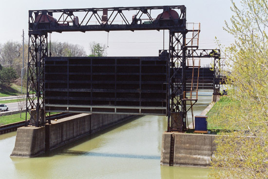
Where the original Erie Canal crossed the Genesee via the aqueduct downtown, the Barge Canal crosses at river level—with the river itself serving to feed water into the canal. What allows for this arrangement is the Court Street Dam downtown, because the dam creates a slackwater impoundment at the appropriate elevation. While the canal is operating, both gates are permanently up (unless the river is high—in which case, the gates act as a lock), but each winter one of the gates is dropped into place, and the canal is allowed to drain.
The picture also shows the concrete foundation for the lift gates. Having recently read a history of the Barge Canal,4 I was more aware than before of all the concrete that went into rebuilding the Erie Canal just prior to World War I. Everywhere we looked we could see the material that sets twentieth-century structures apart from the cut-stone structures of the nineteenth.
Not far beyond the lift gates, the open fields of Genesee Valley Park came into view, as did the parking area where I usually begin my walks to the U of R. One October we hiked this stretch to attend the Stonehurst Regatta, at which time the fields were filled with tents and people. Not many years before, RIT had begun entering its crew-teams—both mens and womens—and as we walked the path along the river we watched them race. We also found ourselves making way for RITs president, Al Simone, driving along in a golf cart and very much in his element—serving as RITs public face at this well-attended event.
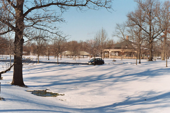
In connection with preparing the current essay, Terry and I returned to the park in late November 2003. I pulled into my usual spot. But because the day was so bitterly cold, we had the place to ourselves:
I hadnt been on any outings recently, and one of the main reasons was that I had lost confidence in my picture-taking process. The photo store I had gone to for years began giving me prints that were too pinkish—too much magenta—for my tastes. For about a year after that I tried a different store, but their prints tended to come back too bluish—too much cyan. Meanwhile, Terry had gotten a digital camera and liked it. Maybe, I thought to myself, I too should switch. In the end, however, I decided to stick with traditional film. I hadnt yet identified a new place to have my pictures developed (though I did so, soon afterwards). But I was determined to move past my uncertainty and start taking pictures again.
On the other side of the river—which we crossed on a pedestrian bridge of much more recent construction—I saw the new signs for the Genesee Valley Greenway, a trail that follows the towpath of the Genesee Valley Canal (and the railbed of the Pennsylvania Railroad). Just before the Greenway passed under the I-390 bridge, we picked up the Barge Canal trail west of the river—this time along the canals southern edge—and we followed it as far as the abandoned railroad bridge that crosses the canal near several large, circular fuel storage tanks. From the railroad bridge, we could look back in the direction we had come. About halfway between us and the river was a pair of lift gates that mirrored the arrangement we had seen earlier. But instead of concrete walls, the canal here was flanked by rock strata. We had reached one of the major projects of the Barge Canal, where its path had to be cut through the strata that create not just the High Falls downtown but also Niagara Falls.
In the early twentieth century, when the old Erie Canal through Rochester was rerouted, the deep cut of this stretch of the new Barge Canal was one of the projects notable engineering feats. For two and a half miles the rock was excavated to depths of 12-36 feet—at a width of 94 feet. Dynamite was used to loosen the rock, and several types of specially-designed machines were used to move the rubble to mounds along the banks. Begun in 1905, this work wasnt completed until 1910.5
On my wintry walk with Terry, I had been taking pictures. When I finally did get them developed, few turned out well enough to include here. But that was OK, because at least I had regained my confidence that the problems with the prints were due to my picture taking—and not to the developing. Fortunately, however, some of them turned out fine—as with the shot of an airplane about to land:
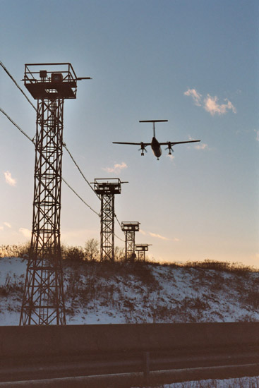
As the picture suggests, we were now losing our light. The time had come to return to our car, and on our drive home we stopped by Loris for our weekly grocery shoppping.
Throughout all this I continued thinking about Americas suburbs. The ones in which I had grown up (and now live) may have been a post-World War II phenomenon, but the middle class of which I was a part had been taking shape for several generations. Nor had public debates been confined to the developments of my lifetime. Instead, controversies had been part of the process all along—as I learned from my research on the structures we had seen. The oldest structure was the park itself. As Rochester matured, it had been slow to create a system of parks. The construction of water, sewer, and street systems during the years just after the Civil War caused the public to resist further expenditures. In addition, when Frederick Law Olmsted and other experts were consulted, the park sites they recommended were well removed from the citys center—and beyond the reach of existing horse-car lines. In the late 1880s, however, the city finally did purchase land for North Park and South Park—which became Seneca Park and Genesee Valley Park, respectively. Local leadership was provided by Edward M. Moore, the man whose statue I pass each time I walk to the U of R libraries along my usual route.6
After the rolling, open terrain along the river was transformed into a park, the original controversy abated. But the new century saw the rise of a new issue—for when the Barge Canal was built, its route south of downtown ended up bisecting the park. Again Olmsteds firm was consulted. To better link the two sections, they recommended a series of pedestrian bridges (likewise constructed of concrete), including one near the mouth of Red Creek:
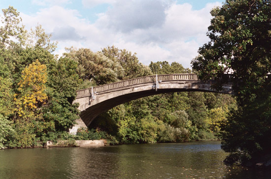
This controversy also resulted in considerable delay, making the stretch of the Barge Canal east of the river the last to be finished—in 1918.7
In our own times I-390 was routed through the same corridor—including a 2,200-foot viaduct passing 55 feet above the river. Constructed by Erdman, Anthony and Associates, Inc., the segmental cantilever bridge made use of post-tensioned concrete—a new development that allowed for the construction of large spans over inaccessible land.8 Thus a plaque, mounted on one of its supporting piers, proclaims the bridge to be the New York Outstanding Civil Engineering Achievement [of] 1981.
Not surprisingly, the actual story of how the bridge came to be built is more involved. After the Outer Loop was first proposed, in the late 1940s, various routes were considered. Some of these put the river crossing as far north as Elmwood Avenue, which would have interfered with the U of Rs expected development. On the other hand, more southerly routes would have interfered with the airport. By 1971, both the state and federal departments of transportation had given their blessings to a route just south of—and parallel to—the Barge Canal. But a coalition of organizations resisted, arguing that the park shouldnt be further disturbed and that insufficient consideration had been given to alternatives (including a tunnel under the river). In 1972 they lost their case in the U. S. Circuit Court of Appeals, and at that point they turned to the U. S. Supreme Court.9
The climax came in 1978. In April, after bulldozers began clearing a broad swath through the park, one of the protestors was arrested.10 The following week, however, saw a bulldozer put out of commission—due to the sugar that someone added to its engine oil.11 Finally, in early May the issue was conclusively settled, when the Supreme Court refused to hear the appeal. Hot dog . . . that takes care of that, said an engineer for the state department of transportation. Not surprisingly, the coalitions lawyer was more circumspect: I rather think the social issue involved here has been obscured by the economic drive to have the road completed irrespective of its impact on the community.12
In early 1981—a year and a half before I moved to Rochester—the completed stretch of highway through the park and over the river was opened.13 Thus when I arrived, I entered a suburban landscape that had been developed, extended, and redeveloped over the course of a full century. In a previous series of essays I had seen how my writing helped bring wholeness to a countryside fragmented by features inserted at different times. But now I saw how the terrain I cover daily poses similar problems. Even the writers home range cries out for integration.
1 William E. Leuchtenburg, A Troubled Feast: American Society Since 1945, Rev. Ed. (Boston: Little, Brown, 1979), pp. 75-76.
2 Lisa Hutchurson, A Building Interest: Scholars Are Tracking the Career of the Very Private Thomas W. Boyde Jr., Who Left a Public Legacy as Rochesters First African-American Architect, Democrat and Chronicle, 3 Feb. 2002, Sec. C, p. 1.
3 Aldo Leopold, A Sand County Almanac and Sketches Here and There (New York: Oxford, 1949), p. 194 (italics in the original essay, Wilderness).
4 Michele A. McFee, A Long Haul: The Story of the New York State Barge Canal (Fleischmanns, NY: Purple Mountain Press, 1998).
5 McFee, pp. 60-62 and pp. 84-85.
6 Blake McKelvey, An Historical View of Rochesters Parks and Playgrounds, Rochester History, 11 (Jan. 1949), esp. p. 1 and pp. 4-6.
7 Marjorie Wickes and Tim OConnell, The Legacy of Frederick Law Olmsted, Rochester History, 50 (Apr. 1988), pp. 11 and 14; and McFee, pp. 85-88.
8 A Century of Engineering in Rochester: 1897-1997 (Rochester Engineering Society, 1997), p. 102.
9 City Proposes New Outer Loop Plan, Times Union, 8 Apr. 1957; John Walter, Outer Loop Link: A Go Ahead, Times Union, 29 Sept. 1970; Bill OBrien, U.S. Okays Road in Park, Democrat and Chronicle, 23 June 1971; and Del Ray, Court Wont Block Highway, Democrat and Chronicle, 4 Jan. 1972.
10 Jackie Farnan, Picket Is Arrested in Loop Protest, Democrat and Chronicle, 20 Apr. 1978.
11 Park Bulldozer Stopped By Sugar in Engine Oil, Times Union, 29 Apr. 1978.
12 Dan Moreau, Court Clears Way for Outer Loop, Times Union, 1 May 1978.
13 John Stewart, New Outer Loop Link to Open, Democrat and Chronicle, 6 Jan. 1981.