|
The Writer's Home Range
Brighton Town Park
by
Its a dangerous business, Frodo, going out of your door, Bilbo Baggins would advise his young nephew. You step into the Road, and if you dont keep your feet, there is no knowing where you might be swept off to.1 Although thats equally true in our day and age, we face the added twist that the terrain we enter is visible by satellite. Thus as an exercise on my new home computer (which, unlike my old, has internet access), I tried finding aerial photos of our house. Several sources offered this service, with the most accessible being TerraServer—a joint effort between the U. S. Geological Survey and the software giant Microsoft.2 If you type in the street address, the appropriate aerial photo appears with a red thumb tack to
mark the spot:
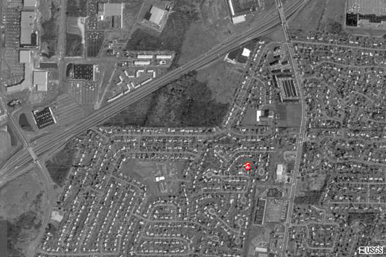
If you want more detail, you can zoom in. The resolution isnt fine enough for people to show up. But you can see individual vehicles—on roads, parking lots, and driveways.
I-390 is the most prominent feature, crossing the aerial photo at an angle, from the lower left to the upper right. Another main feature is East Henrietta Road—toward the right, running north and south, with a slight crook. The various segments of old Clay Road also show up—if you follow the western boundary of our subdivision.
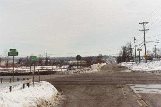
Northwest of our house is a prominent triangle of land, with a large building in the northeastern corner and a dark western half. Running the dogleg of the triangles southern and southeastern borders is Wildbriar Road, while I-390 defines the remaining side. On a snowy day during the Winter of 2004, I stopped on Shell Edge Drive (just short of its intersection with Wildbriar) for a photograph:
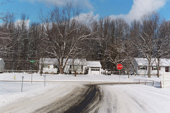
Rising behind the houses is the woods that comprises the dark half of the triangle in the aerial photo. Not long after we moved to the neighborhood, Terry and I parked near Victory Baptist Church (the large building in the triangle) and explored. The stand of hickory, oak, beech, and maple trees isnt old growth, but its far closer to the areas natural cover than the rest of the neighborhood—so we were pleased when we learned recently that the property is being developed as a town park.
Just east of the triangle, Wildbriar intersects East Henrietta (Route 15A). Wildbriar was built as part of our subdivision, but East Henrietta and the road that continues east of East Henrietta (Castle Road) date back to the nineteenth century. As testimony to those earlier times, there stood (until recently) on the intersections northeastern corner the house that belonged to Elijah Little, an early-nineteenth century Henrietta school teacher:
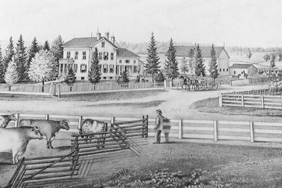
I first saw the above illustration in Eleanor C. Kalsbecks history of the township.3 It shows the Little house across East Henrietta, with Castle heading off to the upper right. On 4 July 2003, I took a picture from about the same location:
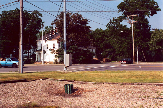
Later that year the house was moved. Yet every time I leave the neighborhood via Wildbriar, the site reminds me that for more than a century Henrietta possessed a stable identity as an agricultural community.
Census figures in Kalsbecks book demonstrated the towns long-term stability.4 From 1820 until 1930, total population averaged 2,165—with a high of 2,513 (in 1850) and a low of 1,794 (in 1920). Beginning in 1940, however, the total population began increasing dramatically:
1940: 2,728
1950: 3,385
1960: 11,598
1964: 17,726
1968: 24,879
The trend has continued—reaching 39,028 in 2000.5 What that reflects, of course, is Henriettas post-World War II transformation into a rapidly developing suburb of Rochester. Whenever I take Wildbriar to East Henrietta, Im reminded of how close downtown is, because in approaching the intersection Im able to see skyscrapers off to the north (a view that also allows me to gauge the days viewing conditions).
Once northbound on East Henrietta, an immediate right would put me onto I-390 North, but on the drive I took for this essay, in January 2005, I continued straight and soon reached the intersection with Jefferson Road. On the southwestern corner is Harris Garden Center, where Terry and I purchase deck plants each spring. A short distance east on Jefferson is the Genesee Valley Market, where Loris Natural Food Center is located. And in the intersections northeastern quadrant is a shopping plaza—with a Burger King, an HSBC branch bank, and a Hallmark store (among others).
Despite all this being rather close to our house, only once did we try walking. On foot, the intersection of East Henrietta and Jefferson turns out to be huge, and because of its turn signals there are always vehicles moving though the crosswalks. In short, the whole arrangement has been set up with cars in mind—not pedestrians.
Continuing north on East Henrietta, theres the Rochester Sports Garden on
the right—where Terry has begun playing ping pong—and on the left
is one of our favorite restaurants, The King and I (though after finally getting
a VCR, weve
tended to go there just for takeout—so that we can watch movies over
supper at home).
After that, the road passes under an active rail line. Currently operated by CSX, it began in the early 1880s as the West Shore but was quickly absorbed by the New York Central. Where the main New York Central line swings north and crosses the Genesee just above the High Falls, the West Shore allows east-west freight trains to bypass downtown. It was the West Shore that brought Henrietta its first train stations. Although the one at Ridgeland no longer exists, it stood near the intersection with East Henrietta.
On my drive, after passing under the railroad bridge I took the right turn that loops back to Brighton-Henrietta Townline Road—which put me onto the high ground at Ridgeland. As a slight detour, I headed west, and after crossing over the current East Henrietta I intersected the old road (now called Balta)—with dead-ends just a block in either direction. Here the terrain crests, offering a clear view south—with the high ground in the distance being the approximate location of Wildbriars intersection with East Henrietta:
Long a stage route, East Henrietta was improved in the early 1850s as the Rochester and Hemlock Lake Plank Road—with a tollgate located near the present-day Monroe Community Hospital.6
On my drive, however, I was actually wanting to head east on Brighton-Henrietta
Townline Road. Going that way, the road descends and passes the southern entrance
to Monroe Community College (to the left). If I had continued toward Winton
Road, Id have come to Macs
II, where Terry and I take our cars for servicing. Instead, I turned left,
onto Clinton Avenue. After passing a subdivision (on the right), the road climbs
over the Barge Canal. Just after that, on the left, is the parking lot for
the towpath trail along the canals northern edge.
From our driveway to the parking lot off Clinton, the distance is just over three and a half miles. There are other access points at about the same distance, so when we want a canal walk that doesnt involve a lot of set up time, we have several sections to choose from. But during the summer of 2003 I realized there was something about this particular stretch I hadnt paid close attention to. If we hiked west, would we come to a side trail into Brighton Town Park?
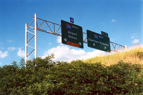
The parking area lies along the east side of the embankment for I-390 North,
so the canal trail toward the west immediately passes under I-390. From there
we could see the highway sign that labels the interstates imminent branching—left
(west) toward the airport and right (east), as I-590:
A little further along the trail we passed Hydraulic Dredge #1, painted in Empire State blue and gold. Because this section of the canal is fed directly by the Genesee (with the first lock to the east being Lock 33, at Edgewood Road, near the Jewish Community Center), this section accumulates river sediment. Hence the dredge.
Finally we came to another highway overpass, this time for I-390 North as it arcs into position for its run to the airport. Right after that, I spotted the asphalt path I was wondering about. On previous visits to Brighton Town Park, we had always come via the Westfall Road entrance. This time, however, we followed the asphalt path, skirted the edge of a lake, and reached the park a different way.
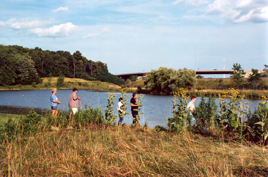
As we approached, we saw people near the waters edge (with the ramp that links I-590 to I-390 South in the distance):
But the people turned out not to be fishing. Instead, they were racing radio-controlled sailboats:
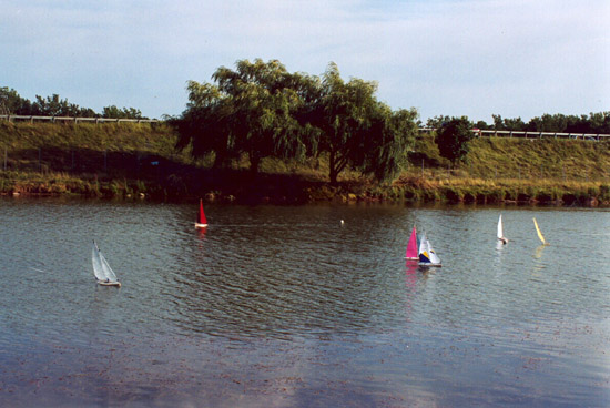
(Also note, along the horizon, the guard rails for I-390 North.)
Finally, we reached the familiar parking area at the lakes northern-most edge. From there, we quickly entered the woods that had first brought us to the park. I had been introduced to this stand of trees when I took the course on Old Growth Forests in Western New York at the Rochester Museum and Science Center several years ago. Although not old growth, it is—like the stand in our neighborhood—the closest thats possible in a developed suburb. Thus the short loop trail allowed us to immerse ourselves, briefly, in what felt like a real forest:
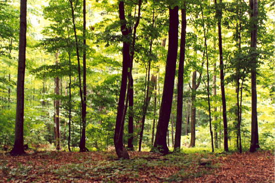
This stand is also special because it offers a rare example of how our society has been willing to place limits (however modest) on the development of automobile highway systems. Here my thoughts returned to A
Sand County Almanac. Probably more than anything else, the development that had forced Leopold to confront the tremendous physical power of modern industrial civilization was highway construction. The publics desire to move across the terrain, at will, seemed to spell an end to whatever wildness remained in the American landscape. In Leopolds view: It is the expansion of transport without a corresponding growth of perception that threatens us . . . .7
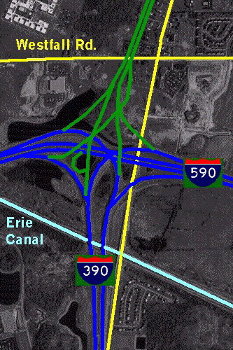
In the case of I-390, the original plan was for it to intersect a suburban
beltway—the Outer Loop—and then to continue all the way downtown.
But because so many houses and neighborhoods would have been disrupted in the
process, the original plan wasnt implemented. Instead, the interstate was
diverted, east and west (thus co-opting the Outer Loop), and the now-unneeded
land north of the exchange was given to the Town of Brighton. This overall
plan change is nicely demonstrated in a website illustration.8 On a TerraServer
aerial photo, the actual I-390 exchange has been highlighted in blue, while
the unbuilt highway is shown in green—with several green lines crisscrossing
the woods that Terry and I now enjoy visiting.
Notes
1 J. R. R. Tolkien, The Fellowship of the Ring (New York, Ballantine Books, 1965), p. 110.
2 Aerial photos can be searched at http://terraserver-usa.com/. I first accessed this site in January 2005.
3 Henrietta Heritage (1977), p. 50. The illustration (and my photo) came from The
History of Monroe County, New York (Philadelphia: Everts, Ensign, and Everts, 1877), Plate 113 (between p. 48 and p. 49).
4 Henrietta Heritage, p. 346.
5 Results for Census 2000 are available online at the U. S. Census Bureau website.
6 Henrietta Heritage, pp. 195-196.
7 Aldo Leopold, A Sand County Almanac and Sketches Here and There (New York: Oxford University Press, 1949), p. 176 (in the essay Conservation Esthetic).
8 See http://home.rochester.rr.com/kreativ/brian/large.jpg. I first accessed this site in February 2005, by following a link in http://www.kurumi.com/roads/3di/i390/html.
|
