|
The Writer's Home Range
Neighborhood Walks
by
I began my habit of taking regular neighborhood walks while pursuing my
graduate studies. Usually these walks came late in the day, as breaks or as
exercise sessions. In Atlanta Id head to Piedmont Park, and in Baltimore I followed a standard route through an upscale neighborhood to Sherwood Gardens near the Johns Hopkins campus. After moving to Rochester, my walks tended to come in the evening—after I had finished teaching my classes—along
the sidewalks of my suburban apartment complex.
My friend Terry also likes to walk, so after we bought our house she developed routes with different lengths—which allows her to pick the one that best fits the time she has available or the amount of exercise she needs that day.
When we go together, its usually the 25-minute route we take. Just for the record, I can list the street names: Emerald Circle to Colonnade to Beaconsfield to Chiltern to Wildflower to Crimson Bramble to Shell Edge to Colonnade to Mountbatten to Colonnade again and back to Emerald Circle. For us, the route has become automatic. But theres no logical pattern to the layout of these streets—so we arent surprised when were stopped by first-time visitors who have become disoriented and need help with directions.
Because Terry has done more neighborhood walking than I, shes more familiar
with the people who live in the houses we pass. Even in our joint walks, shes
likely to stop for chats—especially
if we see Gene in his flower beds or John in his vegetable garden. With others,
we mostly wave and say hello as we pass.
In the process, Ive developed an overall picture of the homeowners en route. They range in age, from parents with young children to elderly individuals. There is also marked racial variation. Although most are White, we pass at least eight Black households, at least three Asian, at least two Indian, and at least one Hispanic—all interspersed. If theres any homogeneity, it lies along class lines: as far as I can tell, the neighborhood is uniformly middle class.
The range in ages, the variety of races, and the similarities in economic class: all these combine to put me very much at ease. Yet as I contemplated starting this new series of essays, I still felt a sense of alienation. Helping me to identify the character of this alienation was Leopolds A
Sand County Almanac. In particular, one of the books main themes was the extent to which people in highly industrialized societies are vulnerable to losing sight of their on-going relationship with nature. Or—as Leopold noted at the outset of the essay Good Oak—we tend to believe that heat comes from the furnace and that breakfast comes from the grocery.1
To help reconnect us to our source of heat, for example, Leopold described his own efforts to cut down a tree killed by lightning. As he sawed through the trunk, he reflected on the trees past—discussing natural events, as well as human. By the time the tree was felled and the wood cut and split, he had offered a sense of where the heat that chases away the morning chill truly comes from.
Although I cant claim to be free of this particular type of alienation, after
our furnace failed a few years ago Terry and I did successfully arrange to
have a new one installed. So even though I dont know, in detail, how our house
is provided with natural gas, at least I know that we can handle furnace problems
without mishap.
On a recent neighborhood walk, however, I realized that I was subject to a type of alienation that Leopold hadnt discussed. In passing the streambed that runs through a culvert under Chiltern, the question occurred to me: Does the water from our yard flow into this stream? To my surprise—and consternation—I found I had no idea.
Although the streams in our neighborhood arent big, the whole area is fairly level—so that heavy rains can result in flooded roads and flooded basements. Our sump pump is meant to solve the latter problem, but we are still vulnerable—as I learned to my great distress when our sump pump failed and had to be replaced, not long after we first moved in.
When the pump operates normally, the water emerges in the backyard and flows down the greenway. As viewed from our rear windows, upstream is to the right (east) and downstream is to the left (west). Only in very wet weather is there a noticeable flow. Even so, the water stays on the surface just a short distance before dropping down a grate.
What happens to the water after that? Despite more than a decade of residence here, I didnt know. I had often written about watersheds—both literal and figurative—yet I now found myself unable to account for where the water from my own yard flowed!
Of course, there was an obvious way of addressing this particular type of alienation. Accordingly, one Sunday afternoon in September 2003, I donned my hat, shouldered my camera bag, stuck a flashlight in my pocket, and headed out. But instead of following our regular route along the streets, I intended to explore the watercourse.
I began by going upstream a short distance. East of our backyard, the greenway climbs gently and broadens. To the north, theres a narrow passage to Mountbatten, which is how the town mowers usually gain access. Mountbatten itself dead-ends a short distance further east. Cars cant get through, but its an easy walk from there to the McDonalds on East Henrietta.
From the top of the greenway, then, I then began my downstream walk, and as I approached the back of our house I took a picture:
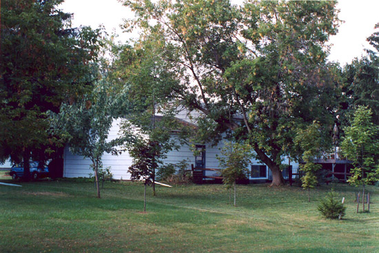
The back door into the garage is visible. So too are two of the downstairs
windows and a portion of the deck. The largest tree—a box elder (right
of center)—was there when we arrived. But we planted the smaller trees—several
of which came from the woodlot of fellow Bath Area Writers Group member, Grace
Fox, and her husband Stanley. The transplants include the ash whose trunk obscures
the back corner of the garage, the sugar maple to the right of the box elder,
and a second ash on the far right.
Returning now to my walk, after passing our house I soon came to the grate. Already I knew where the water flowing into it headed—because the town had recently rebuilt that portion of the drainage system: despite being underground, the flow continued to follow the greenway toward Colonnade.
When I got to the next grate, just this side of Colonnade, I pulled out my flashlight and went to work. Under the grate was a concrete chamber with small pipe openings on three sides. The drainage line I had been following—which opened directly below me—was the highest. To my left, lower down, a second pipe opened. Clearly that line had been following Colonnade—which meant that water from our front yard drained in here (via Emerald Circle and a grate at the junction with Colonnade). A third pipe, opposite the one I had been following, was the lowest. Thus I concluded that the overall downstream flow went through the third pipe and headed under Colonnade.
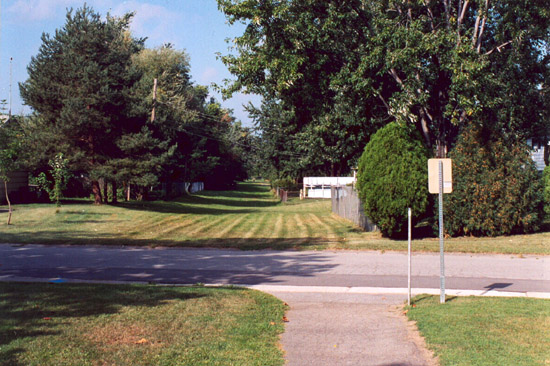
On the other side of Colonnade is a line of houses that back onto a different greenway. That greenway is an extension of the one with the path to the shopping plaza, so I walked around to get a photograph—looking west, downstream—with the lower end of the path showing in the foreground:
Next I followed the greenway—something I had never done before. Just what the water was doing, in the underground pipes, I didnt know for sure. But with several dogs barking at me (from fenced-in yards), I felt too conspicuous to undertake further detailed work—though I did note the presence of a series of grates.
Finally, in the next block the greenway simply ended. Beyond the houses that blocked further progress, I could see Edme Street coming into Shell Edge—near the entrance to Crane Elementary School—so I returned to Mountbatten, followed it to Colonnade and Shell Edge, and walked a short distance on Edme.
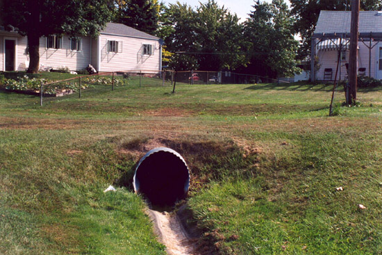
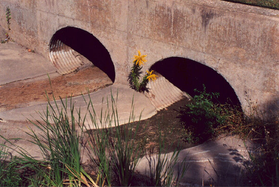
Then, in the field to my left, not far from the school, I saw the curved upper edge of a large corrugated metal pipe, beyond which ran a narrow concrete channel:
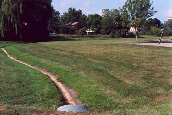
And I also photographed the upstream view:
As I took in the overall layout, I could feel myself relax. I didnt know the exact details, but the exact details no longer mattered: I was reasonably sure that I had located where the water from our yard emerges.
The aim for the rest of my walk thus became extending my mental picture of the downstream flow. After skirting the edge of the school property, the streambed turned left (south) and headed toward Chiltern. Past Chiltern, it followed the edge of Genes lot, in what now felt like a valley—with the houses on either side standing well above the level of the channel.
After a block or so, the streambed turned right (west) and passed under Strawberry Hill Road, through a double culvert. Then it turned left (south) for its run under Calkins—again through a double culvert:
At that point, the stream entered Veterans Memorial Park—with the recreation center for seniors not far from streams west side. As close as all this is to our house, it was new terrain for me, so I continued to explore.
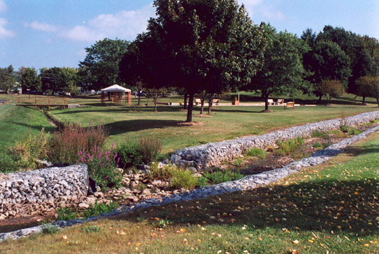
In the park the stream from our neighbornood soon joined a larger stream, whose banks were lined with rock in wire cages. The photograph below (which looks north) shows the stream from our neighborhood, on the left, joining the larger stream at a break in the caged-rock bank:
The flow in the larger stream is from right to left, and I continued my walk by heading left—downstream. That took me along the parking lots behind a series of buildings that face Calkins: the town hall, the town library, and the new town maintenance building.
In the process, the banks of caged rock gave way to tree-lined banks. For
the first time on my walk, the stream stopped looking like an engineered watercourse
and instead began looking more natural. Indeed, as I left the park proper I
startled a heron: it rose suddenly, about twenty feet ahead of me, and flew
low over the streambed for several hundred feet.
But I was still traversing developed terrain. Visible above the golden rods and cattails not far ahead, was the first real bridge I had seen:
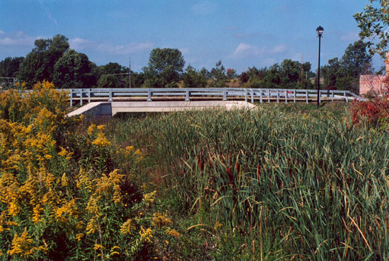
Past the bridge—which takes Red Creek Drive into Calkins Corporate Park—the ground surrounding the watercourse was too marshy to follow. But from the parking lot of the medical buildings nearby (Calkins Health Commons), I could see an even larger stream going under Calkins—headed north.
At that point, I was able to tap into earlier research efforts, as well as past experience. Not far beyond the bridge pictured above, the stream I had been following joins the East Branch of Red Creek. From there the East Branch goes under Calkins and flows generally north and a little west. After skirting the edge of the parking lots at Marketplace Mall, it heads west in earnest, crosses under West Henrietta, and joins the Middle Branch just south of Jefferson. Finally, as Red Creek proper, it heads north. Originally, Red Creek entered the Genesee River just south of Elmwood. But when the Erie Canal was rerouted in the early twentieth century, the creek was made to empty into the canal.
From the creek crossing at Calkins, I returned home by following neighborhood roads—which took twenty minutes. Later in the day, I drove the same route to figure out that return distance: a mile and a half.
Despite the shortness of my walk, I felt good about it. Until then, I had known where our house stood, relative to the various ways we drive in and out of our subdivision. But the mental disconnect between the roads and the pattern of the local water flow had been pretty much complete. Now, however, the harshest edge was off my alienation: I knew where I lived in my own watershed.
Notes
1 Aldo Leopold, A Sand County Almanac and Sketches Here and There (New York: Oxford University Press, 1949), p. 6.
|