|
Genesee Vignettes
Personal Reflections on the Genesee River
A series of eighteen essays by
XIII. A Visit to Genesee, Pennsvlvania
In taking my vignettes upstream as far as Wellsville, I had reached the
edge of my personal experiences. No longer could I draw on events since
moving to Rochester. Nor could I draw on events from my childhood, events
from Grandma’s past, or events involving more distant ancestors.
By Wellsville I had reached the end of all these. Yet the Genesee River
didn’t end there, leading me to wonder: instead of writing about
Rochester or about the area where Grandma had lived, could I shift the
focus of my vignettes one final time and try my hand at writing about
the headwaters of the Genesee?
The idea that came to me was to rely on the writings of others. Even
if my own experiences no longer sufficed, there were others whose experiences
had certainly enabled them to write about the river’s uppermost
reaches. One possibility was a new book in area bookstores: Runnin’
Crazy: A Portrait of the Genesee River, by Ruth Rosenberg-Naparsteck.
Additional possibilities were two older books that I had no difficulty
finding used: The Genesee, by Henry W. Clune,20 and
A River Ramble: Saga of the Genesee Valley, by Arch Merrill.21
Merrill was a long-time journalist for the Democrat and Chronicle
who wrote numerous books about the region. But in his 1974 New York
Times obituary, only A River Ramble was mentioned by name.
Originally serialized in the D&C, it was based on a trip
that Merrill took in 1943. His plan was to walk from the river’s
source to its mouth. But helpful passersby had given him rides, despite
wartime gas rationing.
The “Foreword” to Merrill’s book had been written by
Henry Clune, a Rochester native, a novelist, and—like Merrill—a
long-time journalist for the D&C. In his own book—again
like Merrill—Clune emphasized the river’s human geography.
But where Merrill’s book was a slim sketch (109 numbered pages),
Clune’s offered a much fuller treatment (338 numbered pages), as
befitting a volume in the “Rivers of America” Series.
Begun in the 1930s under the editorship of Constance Lindsay Skinner,
the series aimed at telling the history of the American people by recounting
their experiences along rivers. After Skinner’s death in 1939, others
assumed her editorial duties (including Stephen Vincent Benét).
By the time of Clune’s contribution, in 1963, the editor was Carl
Carmer—himself a notable writer on Upstate New York—and the
total number of volumes in the series had reached 54. (With publication
of the last volume, in 1974, the total reached 65.)
At first glance, the most distinctive feature of Naparsteck’s book
was its rich visual record—more than 200 photographs, maps, and
other illustrations. As the most recent of the three, it also carried
the river’s story the furthest forward in time. Clune, for example,
had done little more than mention the Mount Morris Dam. But Naparsteck—who
currently serves as city historian of Rochester—devoted an entire
chapter to its construction. She also featured the most important new
development since the 1960s, namely, the transformation of Rochester’s
portion of the river into a series of recreational and entertainment sites.
Although differing from each other in various ways, all three Genesee
classics shared at least one feature that set them apart from my vignettes:
where I had begun with the river’s mouth and worked my way steadily
upstream, Merrill, Clune, and Naparsteck had begun with the river’s
headwaters. More specifically, each had visited the same spring on the
same farm near Gold, Pennsylvania—a spring that fed the Middle Branch
of the Genesee—which is what had suggested to me the idea of using
their books to continue my writing.
The trouble was that my research also led me to a multi-volume study
of the Genesee watershed that the Buffalo District of the U.S. Army Corps
of Engineers had prepared in 1969.22 In contrast to the three
Genesee classics, its maps clearly labeled the East Branch—through
Ulysses, Pennsylvania—as the main channel. Subsequent recourse to
my Pennsylvania atlas, to USGS topographical maps, and to the geology
article I had used to write an earlier vignette confirmed the existence
of this second choice.
Although the discrepancy isn’t one I’m prepared to resolve
in this essay, I mention it because it sent me a clear signal: I wasn’t
going to be able to draw on published sources alone. If I wanted to write
about the river south of Wellsville, I’d have to size up the terrain
for myself.
I should have guessed as much. In looking back over my notes on the Hemingway
biographies I read in 1975, I had been reminded of “the fundamental
edict of his creative writing,” namely, that a writer “should
write only about what he has known.”23 Or—as Hemingway
himself put it—”You’ve got to see it, feel it, smell
it, hear it.”24
In short, there could be no substitute for additional trips—which
was just as well, because preparing the earlier vignettes had generated
questions that only additional trips would allow me to answer. Fortunately,
all this came into focus just before I gave mid-terms during Fall Quarter
1998—which meant I still had a Saturday free. The final step was
to consult Terry, and her interest in a trip clinched it.
Although we had a lot of driving to do, we didn’t push for an early
start. Instead, we followed our usual Saturday morning routine and then
ran a short round of errands—which put us on the road about 12:30.
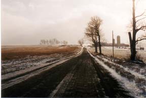
As our first stop, I proposed the Portageville bridge. I wanted to confirm
something I had said in an earlier vignette, namely, that both piers for
the old canal aqueduct and railroad bridge could indeed be seen from the
highway bridge. We quickly spotted one of them, midstream. The other—in
the brush to the left—didn’t stand out. But it was definitely
visible, so no change was necessary.
At Terry’s suggestion we then walked down to the water’s
edge. Here the river traversed a horizontal layer of sandstone, making
it quite shallow most of the way across—and if the day hadn’t
been so cool we might have tried wading. In my earlier vignette I had
described the river as being “dark green.” But now I asked
Terry how she’d characterize its distinctive color. “Slate
green” was her suggestion, which gave me something to change after
all.
As we approached Caneadea—along Routes 19A and 19 south of Portageville—I
told Terry about a side trip I wanted to try. From A River Ramble
I had learned that the Seneca village where the council house at Letchworth
originally stood was located “on the river’s bank, opposite
the present site of Houghton College and two miles northeast of . . .
Caneadea.”25 Just before entering Caneadea, we turned
left on to Council House Road, and within minutes we found the granite
boulder and metal historical marker that Merrill had mentioned.
Our next stop was Chamberlain Cemetery, where I hoped to take more pictures
of the Hopper tombstones. But the overcast day didn’t lend itself
to detailed inscription shots. In fact, the clouds were getting so dark
and low that I became uneasy. As useful as it was to be refining my previous
vignettes, I wasn’t yet doing what I needed to do in order to compose
a new vignette.
My sense was that new writing required exploring the river at Genesee,
Pennsylvania. Although my sources disagreed about which branch was the
main one, all viewed the Genesee as becoming a full-fledged river at the
village of Genesee. To make sure we’d have as much daylight there
as possible, we drove without further stops or side trips—though
I did try to stay alert to the unfamiliar territory south of Wellsville.
After York Corners, New York, we entered hillier country, and the fall
colors seemed richer than in Rochester—perhaps due to the higher
elevation. I also noted that the long-distance views were no longer clear.
The hills were becoming misty, and we began picking up rain on our windshield.
At Shongo, New York, the Genesee was still a river—through definitely
smaller in scale. Soon after that, we reached the state line. Route 19
became Route 449, and very quickly we found ourselves in Genesee. Had
we gone straight, we would have been stopped by the barricade that blocked
access to the new bridge. Instead, we turned right—onto Main Street—parked,
and explored the new bridge on foot.
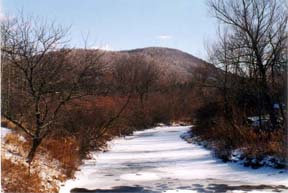
As at Shongo, the Genesee in the village of Genesee still had the feel
of a small-scale river. Upstream, along its west bank, lay a side road—which
we soon followed back to Main Street—and rising above the houses
was the gentle curve of a nearby hill:
In the process of walking toward the village center, we crossed a second
bridge. “Is this the river again?” I wondered aloud. After
some study, we decided it wasn’t. Instead, we identified it as the
West Branch of the Genesee—which was making its way around the hill
we had seen from the first bridge.
This sort of field work was exactly what I hoped to accomplish. Figuring
out the lay of the land, on foot, wasn’t emotionally high powered.
But it did feel satisfying—especially because I knew I was making
good decisions about where (and where not) to linger.
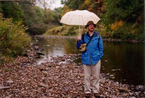
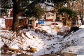
At the intersection just past the village center we turned left and immediately
crossed a third bridge—this one over the Genesee, upstream from
the West Branch’s confluence. Here the scale was more like a creek
than a river. We spotted a fishermen’s trail, and after making our
way down to the streambed, I asked Terry to take a picture of me—which
she did, looking upstream (with me holding an umbrella, because of the
light rain that was falling):
Finally, we completed our circuit. At the brick schoolhouse, we turned
north, which took us past a row of houses with their front yards shaded
by tall maple trees—reminding me of Grandma’s street in Campbell.
Further along we passed a factory of some sort, and I couldn’t tell
if it was shut down permanently or just closed on weekends. After turning
toward the first bridge—and just before reaching it—we passed
an abandoned railroad station. We then returned to the intersection near
which we had left our car.
Along the way I noticed that the turnoff for Route 244 was marked with
a sign giving the mileage to Hornell. Since we still had some daylight
remaining, I suggested we try it—and Terry was game. Just before
reaching the state line, we came to a fourth bridge. This time we were
crossing Cryder Creek, which joins the Genesee north of the village.
In leaving Pennsylvania, Route 244 became Route 248A, and then, after
Whitesville, New York, it became Route 248. As 248A it followed Cryder
Creek; as 248 it followed Marsh Creek. For a while, Marsh Creek widened
into a long lake—which suggested we were nearing a divide. Sure
enough, within a few miles the road began following Bennetts Creek, through
Greenwood, New York, and from there to the Canisteo River at Canisteo,
New York.
In my own mind, I was now thinking that our trip was over. But as we
took Route 36 through Hornell, I realized that we still had more than
an hour of driving ahead of us. “The rain has let up, and we’ll
be going by Stony Brook Park,” I said to Terry. “Would you
like to do some walking, as a break?”
Because it was so late in the day, the attendant at the entrance booth
waved us through, without our having to pay. For a few minutes I thought
we might have the place completely to ourselves—in striking contrast
to the one other time we had come, on a Labor Day weekend. But as we reached
the far parking lot we finally saw a handful of cars.
We took the main trail, right up the glen—past the swimming pool
that had been drained for the season and then past the waterfalls. On
our earlier visit, we had returned to the parking lot via the East Rim
Trail. This time, to be different, we tried the West Rim Trail. After
a strenuous climb, we found ourselves following the upper edge of the
gorge. At times we could see almost straight down, to where we had been
hiking just a few minutes earlier. Through gaps in the hemlocks ahead
of us we also glimpsed the valley north of Dansville, thus reminding me
that in driving from Hornell we had returned to the Genesee watershed.
XIV. All Arms, No Octopus
How do we create knowledge out of experience? The trip I described in
the last vignette illustrates one way the process can start: beforehand,
as I reflected on where my project stood, I had become aware of gaps that
only another trip could fill. I had then brought into better focus the
stops I needed to make and the routes I needed to follow. In other words,
I had prepared an itinerary.
Although I’ve found itineraries to be useful tools for doing land
research, the trips themselves are always more complex. For example, the
one to Genesee, Pennsylvania, rested on the good performance of my car,
and I had been having a hard time starting it after driving a while and
stopping. If my car were to fail, then the itinerary I had prepared wouldn’t
mean much.
Another aspect of the trip was Terry’s presence. She liked the
basic trip idea. But she didn’t see my itinerary until we were well
on our way. Would my choice of routes and stops interest her? Would she
have suggestions of her own? Still another aspect was the land itself.
Would road construction send us on detours? How cooperative would the
weather be?
From experience I knew that uncertainties such as these could quickly
undercut my efforts at land research. Fortunately, this particular trip
threw us no curves. Although I did have to alter my expectations here
and there, that was O.K.—because the main purpose of an itinerary
is to facilitate negotiations between the things I hope to accomplish
and the circumstances I actually meet.
Where itineraries are cognitive tools prepared before going
on trips, my handwritten “trip notes” are similar efforts
afterward. Just as my trip experiences are more complex than
any itinerary, so my trip memories are more complex than any notes. The
notes do help me recall details long afterward. Nevertheless, when I write
my essays, things about the trip often surface that I hadn’t expressed
on paper before.
To put the itineraries and trip notes in their proper perspective, both
count as parts of the trip experience. By contrast, essay writing is a
separate cognitive effort, the purpose of which is to explore the trip’s
various dimensions or levels of meaning. Essays can function in this way
because they constitute a middle ground, between the objective world “out
there” and my subjective inner world. On this middle ground, my
experiences and my ideas are able to tug and pull on one another. Knowledge—truth
as I understand it—emerges as a result.
If kept strictly private, of course, my essays would become too strongly
tilted in favor of my inner world. But I don’t keep my essays strictly
private. I show them to Terry, encouraging her to apply her editorial
skills; I give them to family members to read; I submit them for publication
in The Crooked Lake Review and—most importantly—I
take them to meetings of the Bath Area Writers Group. Even if there’s
little explicit feedback from the group, just the act of reading my words
aloud to them relevels the playing field.
In the case of the previous vignette, the group’s responses turned
out to be more vigorous than usual. They believed I hadn’t been
as clear as I should have been, regarding why the trip was important.
They also believed I hadn’t sufficiently emphasized how I felt.
To some extent I’ve followed their suggestions. Yet the fact remains
that my intention all along was to discuss in the next vignette—in
this vignette—the ideas that gave the trip its full meaning.
Clearly I hadn’t put Genesee, Pennsylvania, on my itinerary out
of the blue. Instead, the trip was part of an on-going writing project,
for which I had already done considerable research, and in the course
of that research I had come across a remarkable illustration in Bradford
B. Van Diver’s book Roadside Geology of New York.26
By showing a cutaway view of the underlying strata—as well as the
main relief features of the watercourse—it offered a striking full-length
portrait of the Genesee River:
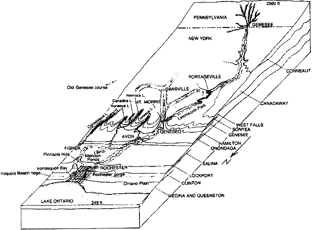
Block Diagram of Genesee River Basin
courtesy, Kendall/Hunt Publishing Co.
In the illustration, downtown Rochester stands on Lockport dolomite—the
formation that surfaces along the upper edge of the high ground, above
the Ontario Plain. Avon, in turn, stands on Onondaga limestone—the
formation that surfaces near the base of the Allegheny Plateau. What the
river does as it runs through Letchworth State Park is to drop off the
plateau. Finally, in the headwaters region of northern Pennsylvania, several
smaller streams come together near the village of Genesee.
That last feature, in particular, started me on a long train of thought.
The first idea to surface was how the river near Genesee looks like a
many-headed hydra. In my high-school sophomore English class we had read
Edith Hamilton’s Mythology,27 and after consulting
my now-ragged paperback copy I was reminded that Hydra was one of the
monsters slain by Hercules. But even though the creature’s schematic
proportions fit Van Diver’s illustration, the emotional values of
the ancient story did not: on my trip I hadn’t felt like Hercules
confronting a monster.
Then I realized that Van Diver’s illustration didn’t show
the river in its usual orientation. Most maps put north at the top, not
the bottom. Accordingly, the schematic creature didn’t have multiple
heads; it had multiple legs. That new image brought
a new idea to the fore, one that felt more relevant than the Hydra idea—because
it arose out of my personal past, rather than ancient mythology.
At college one of my acquaintances was an English major. I can’t
say I knew Charlaine well, but we were on friendly terms. Since then I’ve
realized that some people become English majors because they’re
interested in literary criticism, while others do so because they’re
interested in writing. Charlaine was one of the latter. Not only has she
gone on to become a writer of murder mysteries, but even when I knew her
she evinced more a poet’s sensibilities than a critic’s.
Although the exact circumstances of her remarks are no longer clear to
me, I do recall the general setting. We were in a dorm room, probably
during my junior year. We weren’t by ourselves; others were around;
my whole experience at Rhodes was social in that way. Did she address
herself directly to me, or did I merely overhear what she said? I’m
not sure. At any rate, in my presence she characterized me as “all
arms and no octopus.”
I’ve long known that my essays are strongly autobiographical—which
means, in part, that I’ve shouldered a distinctive literary obligation.
As the writer and journalist Tom Wolfe once said, “if you use the
first person [in your writing] you’ve turned yourself into a character,
and you have to be ready to make that character an important part of the
narrative.”28
In my case, the need to characterize the “I” of my essays
turns out to be cognitive, as well as literary. I’ve not just made
myself a character in a story; I’ve also made that character a truth
seeker. But as a cognitive agent, the “I” of my essays has
a complex identity. By going on trips, I’ve place myself physically
on the terrain “out there,” and by conducting trains of thought,
I’ve tapped directly into the inner world of my imagination. As
a result, the “I” of my essays is neither purely subjective
nor purely objective. Who, then, is the truth-seeking “I”
of the middle ground?
Having Charlaine’s remarks surface in my train of thought tended
to force the issue, because I found her particular choice of words ambiguous
and unsettling. The interpretation I preferred was that my intellectual
interests have led me to be active—and hence visible—in the
world “out there” but that my introversion has led me to avoid
putting in too frequent an appearance. In other words I tend to believe
that Mr. Octopus exists and simply chooses to keep himself hidden most
of the time. But what if he doesn’t exist? What if there is no integrating
force at the center of my various activities?
With good ideas starting to surface, there was one more step I needed
to take before writing the new essay: I had to let experience from the
world “out there” start tugging and pulling on my inner ideas.
Clearly Van Diver’s illustration and the octopus image were schematically
congruent. But I needed to see if the octopus image resonated with the
physical place—which is what I had in my mind for our visit to Genesee,
Pennsylvania. The result was low-keyed, yet definite: when we spotted
the trail leading down to the river bed, I felt a desire to go on record.
The time had come for Mr. Octopus to put in an appearance, so I deliberately
asked Terry to take my picture, standing at the place where the river
was forming itself out of its various branches.
With that act, an important question became fully engaged: who is the
“I” of these essays? Already a portion of the answer should
be clear: I’m an historian. As such, my tendency is to recast the
original question: not “who is the ‘I’ of these essays?”
but “when did he first appear?” I suppose I could respond
by talking about my birth or my earliest memories. But that would take
me too far back. When had I first developed to the point that Charlaine’s
characterization fit?
As the question got recast, I realized it wasn’t one I had considered
before—something a researcher always takes as a good sign. In answering
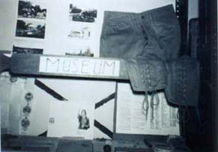
it, what first came to mind were the museums I had made as a boy, in Mississippi
and earlier in Oklahoma. My museums were collections of objects, each
with its own label, that I arranged on a set of metal utility shelves,
as shown in the following photo taken in 1962:
Although I was getting warmer, I wasn’t quite there. The museums
felt more like one of the river’s headwater branches. Could I identify
that branch? Then could I move further downstream, pick up the other headwater
branches, and identify where the river itself formed?
In Ohio (before moving to Oklahoma in 1958) I remember accompanying Dad
to a creekbed to collect fossils. Although I enjoyed the outing, clearly
the idea came from him—not from me. By contrast, the bottle-cap
collecting I started at about the same time definitely came from me. On
family trips I remember eagerly searching roadside picnic areas. I also
remember Dad’s disapproval—and now it’s obvious why
he objected: we wouldn’t have stopped unless we were about to eat,
yet here I was grubbing around on the ground! So—like Charles Darwin—I
can claim: “The passion for collecting. . . was very strong in me,
and was clearly innate. . . .”29 But I’m not really
tempted to call the “I” of my essays a “Collector.”
Instead, collecting is the appropriate label for the primary headwater
branch.
Another early instance of collecting came during my visit with Grandma
Cornell after my brother John was born in 1958. On that visit Grandma
gave me a commemorative half dollar and a book about coin collecting,
thereby starting a hobby I continued for several years. Earlier—for
my birthday in 1956—my maternal grandparents had given me a book
on natural history, and I recall asking my parents to read “my nature
book” to me at bedtime. These memories suggest that books constitute
a second headwater branch.
Finally, my thinking about visits with Grandma Cornell led me to recall
an experience that involved books and collecting but that was bigger than
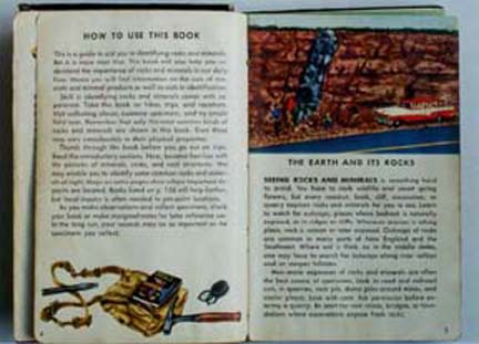
either. Another book Grandma gave me was a used copy of Rocks and
Minerals, from the “Golden Nature Guide” series.30
This must have come later, because inked onto the title and contents page
were comments that it had been acquired by the school library at Coopers
Plains, New York, in February 1958 and had been discarded in June 1960.
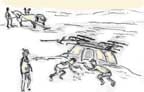
Whatever the date, I learned from the book that geologists collect samples
in the field using special hammers (see the illustration on the bottom
left):
In Grandma’s barn I had seen something similar—though much
larger—namely, a pick ax. Because Dad wasn’t around and because
natural history wasn’t one of Grandma’s interests, I’m
fairly certain that the idea for the outing came from me (though likely
I was influenced by the other illustration above).
What Grandma and I did was to go to the exposed strata along Route 415
between Campbell and Coopers Plains. Although she was the driver, I count
car travel as a third headwater branch.
We parked in the lot of the county highway department, and while Grandma
waited in the car I tried my hand at collecting rocks using the pick ax.
In that experience I now see the various branches of my early interests—collecting,
books, and car travel—merging to form the river of my identity in
these essays.
If I had to choose one word to characterize such activities, I’d
have no trouble at all. Such activities are “projects.” I
consider the rock-collecting trip with Grandma to be one of my very first
projects, and ever since then the pursuit of projects has lain at the
heart of my intellectual efforts.
But using the term “projects” also raises a problem of terminology.
What do you call the person who pursues them? To our ears it sounds odd
to call someone a “projector.” By contrast, I knew that Benjamin
Franklin wouldn’t have been so discomforted. For example, he wrote
in his autobiography: “It was about this time that another Projector
. . . came to me, with a Request that I would assist him. . . .”31
For that reason, I decided to shift my train of thought out of my personal
past and into the historical past.
The language of “projects” and “projectors” wasn’t
original with Franklin. As he noted in his autobiography, among the books
he had read while growing up in Boston was “a Book of Defoe’s,
called an Essay on Projects.”32
Recourse to the main library at the University of Rochester turned up
a facsimile copy. Originally published in 1697, it was one of Defoe’s
earliest works, and in it he had characterized a “Projector”
as someone “who having by fair and plain principles of Sense, Honesty,
and Ingenuity, brought any Contrivance to a suitable Perfection. . . .”33
Also of interest was his characterization of the times as “The
Projecting Age,” which “swarms with such a multitude
of Projectors more than usual.”34
Although Defoe had taken his “Projecting Age” back only to
1680, I knew from The Oxford English Dictionary that under the
word “project” (defined as “Something projected or proposed
for execution; a plan. . . “) the earliest example was dated 1601.35
Similarly, the earliest example under “projector” (defined
as “One who forms a project, who plans or designs some enterprise
or undertaking . . . ”) was dated 1596.36
All this sounds odd to us because in more recent times English word usage
has changed—to the point that in the late nineteenth century a French
word was borrowed to restore the old meaning. Here I refer to our term
“entrepreneur.”
In my “History of American Technology” course I often assign
students the first chapter of J. W. Gough’s book The Rise of
the Entrepreneur.37 After summarizing the various ways
the term has been used, Gough offered the best definition I’ve come
across: “the entrepreneur was the individual whose energy, and willingness
to assume risks and responsibilities, enabled an enterprise to be launched.”38
More than just defining the term, Gough also aimed at establishing when
entrepreneurs first became well-defined figures in English economic life,
and unlike Defoe he focused on the Renaissance. “Between about 1540
and 1640 . . . ,” Gough wrote, “there was a striking expansion
both of trade. . . and of industry, including the development of a variety
of new manufactures and processes, which were very largely the creation
of projectors or entrepreneurs.”39
As Gough pointed out, an entrepreneur wasn’t necessarily a capitalist,
a manager, an engineer, or an inventor. Although he might be any of these,
that in itself didn’t make him an entrepreneur. Generally speaking,
the Renaissance was a time of change in Europe—not just economic,
but also political, religious, and intellectual. The Middle Ages were
giving way to Modern Times, and public enterprises of all sorts were becoming
more numerous, more varied, and more complex. These circumstances created
a need for agents to orchestrate the new enterprises—agents who
were then called “projectors” or “undertakers”
but whom we would call “entrepreneurs.”
As far as I know, I’m not directly descended from any of the Renaissance
entrepreneurs. Although Grandma Cornell traced our family lines deeply
into the colonial era, her research tended not to take her across the
Atlantic. But even if I were to pick up where she left off, I wouldn’t
expect to find our lines going back to the people Gough mentioned.
In any case, however, a direct, genealogical tie would miss the point.
In traveling to Genesee, Pennsylvania, I had reached the Renaissance entrepreneurs
via a different route. What I had traced was my cultural ancestry,
as distinct from my genetic ancestry. This isn’t to say that I had
adopted the identity of the economic entrepreneurs. Instead, I had become
a reflective intellectual. In so doing, however, I had made projects the
heart of my method: to understand a topic, my tendency was to undertake
projects involving that topic. Although the Renaissance entrepreneurs
aimed at economic gain, they too learned about the world through the projects
they undertook. In that sense, my epistemology was the same as theirs—making
Mr. Octopus very definitely a Projector.
XV. The Three Branches of the Genesee
In late December 1998 I returned to Genesee, Pennsylvania. The day was
biting cold, with snow on the ground, and at first the sky was overcast.
But as I left Rochester, chinks of blue began opening up, and soon I was
enjoying long stretches of bright sunshine. Since Terry was in Knoxville,
visiting her parents, I was on my own. Although I often used solo trips
to pursue trains of thought, I didn’t have anything special to work
on this time. Instead, I just listened to the car radio and let my mind
wander.
My plan for the day was to take another look around the village and then
explore the river’s three branches. The first thing I did was to
drive the circuit that Terry and I had walked in October. Next I continued
south on Route 449 and immediately climbed the hill that separates the
river’s Middle and West Branches. There—on the other side
of the road, just before its steep descent back into Genesee—I found
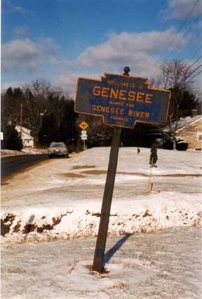
a metal marker telling me that the village had taken its name from the
river and had been founded in 1853.
Later I stopped at the public library on Main Street and asked to see
any local history material they might have.
The librarian brought me a booklet, which I read at a long wooden table
in the back room. From the booklet I learned that the site had once been
a campsite for the Delaware Indians and that the European-American settlement
had originally been called “Genesee Forks.” As the village
developed, it became “a large shipping point for its size”
and “reached its possible peak of growth in 1907.”40
Back in my car, I took State Routes 1010 and 1011 to nearby Hickox, Pennsylvania,
where the East and Middle Branches join. After walking across the pair
of bridges just above the confluence, I decided that the view up the East
Branch looked more river-like:
In Genesee I had gassed up at the Sunoco station and had considered stopping
for lunch at the deli inside. But because I was eager to explore new territory,
I had decided to hold off. Where Route 49 joins Main Street in Ulysses,
I spotted the Corner Cafe Family Restaurant. Before stopping, however,
I first checked the hours of the library across the street—and discovered
that it was closing in ten minutes! Fortunately, the librarian had no
trouble locating and photocopying for me a short booklet on the town’s
history.
“What is now Potter County was purchased from the Indians in 1784
. . . ,” I read over my macaroni-and-cheese special.41
The original treaty was signed by the Iroquois, but later the Delaware
also formally relinquished their claims. Meanwhile, European-American
settlers established the village of Lewisburg—which was later renamed
Ulysses. “From 1833 to 1840,” I read further on, “Ulysses
began to assume the position it long occupied as the chief town in Northern
Potter.”42
After lunch, I used the map in the booklet to follow the East Branch
through Ulysses. I decided that the best place for picture taking was
from Main Street, and as I looked upstream—into the backyards of
nearby houses—the channel appeared so modest as to no longer warrant
being called a river:
I had made the trip primarily to size up for myself the river’s
three branches. I hadn’t planned to explore their ultimate sources;
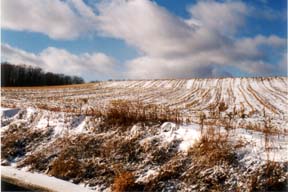
I was saving that goal for another time. Although I did drive the extension
of Main Street up the hill, I deliberately stopped short of the crest
and recorded my point of furthest advance by taking a picture of last
season’s cornfield:
From Ulysses I took Route 49 to Gold, on the Middle Branch. Except for
a general store, there wasn’t much to explore. As in Ulysses, I
again drove south, up a hill, and took a picture looking toward the crest—though
by now the direct sunlight had given way to low-lying clouds and the threat
of a snow shower:
I had begun my trip in a contented mood, and along the way my overall
sense of satisfaction had grown. “How lucky I am,” I said
to myself, “to be driving the terrain I want to write about, taking
pictures, stopping at libraries, even enjoying a meal at a local restaurant—all
at a leisurely, reflective pace.”
As that thought surfaced, I toyed with the idea of heading home—and
actually began driving Route 449 from Gold back to Genesee. But when I
came to the turnoff to Ellisburg, Pennsylvania, I developed second thoughts.
“Your plan for the day was to explore all three branches,”
a voice inside me said. “Do you really want to skip the West Branch?
There’s still plenty of daylight left. Shouldn’t you give
it a try?”
“OK, OK,” I answered, as I turned. Before I knew it, Raghill
Road had climbed and then descended into Ellisburg. Smaller than Genesee,
it too was a place where several streams joined. But I made no effort
to sort them all out. What I had come to do was to follow the West Branch
downstream to Genesee.
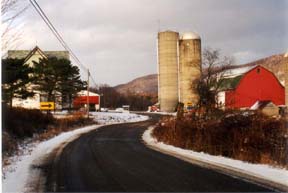
From the outset, Route 244 out of Ellisburg felt different. Not only
was it narrower and more winding than the highways I had driven earlier
in the day, but the main features of the terrain were also more immediate.
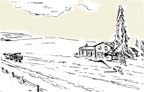
At one place the road went right through a farm—the barn and silos
to the right and the farmhouse to the left:
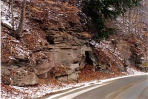
At another place the road skirted a heavily wooded hillside that had
been partially sheared away, revealing bare strata along the shoulder:
What I was seeing was really no different in kind from what I had seen
on drives throughout the region. The difference was the intimacy I now
felt with the terrain. Neutral contentment quickly gave way to excitement,
and upon reaching Genesee I turned right around and drove the same route
back to Ellisburg!
Until then, I had been considering only the East and Middle Branches
as candidates for the river’s primary channel. The West Branch hadn’t
been in the running. But now I wasn’t so sure—because my drive
along Route 244 vividly put me in mind of Thomas Jefferson’s vision
for America.
Jefferson believed that farming was the ideal way of life. “Those
who labour in the earth are the chosen people of God, if ever he had a
chosen people. . . ,” he wrote in his 1785 book Notes on the
State of Virginia.43 More than that, he saw farmers as
making the best citizens. “The small land holders,” he remarked
elsewhere, “are the most precious part of a state.”44
According to Jefferson, farming was important because it kept people
close to nature—which he saw as the true basis of American culture.
“Not institutions, but nature itself,” Daniel J. Boorstin
would later explain, “was the receptacle and vehicle of values.”45
The vastness of the country—which Jefferson, as president, would
make even vaster, through the Louisiana Purchase—meant that most
Americans didn’t have to live in cities. By remaining agricultural,
America could thus preserve its distinctive identity as “Nature’s
nation.”46
Although they’ve since been eclipsed in importance by the twin
forces of urbanization and industrialization, farms and the earth’s
natural features still compose the basic fabric of the Genesee watershed.
The river may be known worldwide for the largest city along its banks—and
from the outset Rochester may have had its identity rooted in manufacturing
and business enterprise—but wherever I’ve gone in the Rochester
area I’ve never been far from working farms or natural habitats.
In some sense, these were things I already knew. But I knew them only
matter-of-factly. What the road between Ellisburg and Genesee had done
was to dramatize these familiar features, reminding me that they had once
been central to a powerful vision of American culture. Although now usually
obscured, that vision still exists—and along Route 244 its presence
had been made known to me. Thus the terrain of the West Branch possessed
a special quality, making its designation as one of the Genesee’s
three branches fully appropriate.
XVI. Chorography
By surveying the three branches of the Genesee, I had seen for myself
how each could be considered the mainstream. The East Branch was the choice
of professional mapmakers, probably because its gradient was the most
moderate and because it continued the river's overall directional trend.
But other criteria pointed to the Middle Branch—namely, the criteria
of choosing the central branch and (for a northward-flowing river) choosing
the branch that reached furthest south. Finally, my own experience suggested
the West Branch's primacy, because in driving along it I had seen most
clearly the soul of the place, the underlying fabric of the terrain.
I suppose I could have made my own choice, of one branch over the others.
But I wondered instead what would happen if I held off. After all, I was
now writing about a watercourse quite different from either the Genesee
through Rochester or the Conhocton through Campbell. Rather than a river
with a single, well-defined channel, the Genesee in Potter County, Pennsylvania,
consisted of several streamlets, no one of which exercised clear dominance.
In starting my new train of thought, the West Branch again played a critical
role. Because it had put me in mind of Jefferson's vision for America,
I asked myself where his distinctive approach to knowledge had come from.
"Surely," came the reply, "if anyone deserves to be called a child of
the Enlightenment then Jefferson does," with his book Notes on the
State of Virginia offering a good example of experienced-based rationality.
The Enlightenment, in turn, had been strongly influenced by the Scientific
Revolution of the seventeenth century, and an article in Isis—the
main professional journal in my academic field (the history of science)—had
already shown me how the Scientific Revolution imparted to human experience
an epistemological authority it hadn't previously possessed.
By long tradition, the reliability of knowledge rested on the reliability
of the sources employed. "For medieval and Renaissance scholastics, as
for Aristotle himself," wrote Peter Dear (whom I had met when we were
both graduate students, he at Princeton and I at Johns Hopkins)—"attaching
the name of an authority to a statement of experiential fact rendered
it probable and hence suitable for use in argument."47 In short,
the authority of factual statements arose from the occurrence of those
statements in books that were viewed as being authoritative.
But during the Scientific Revolution, the members of the Royal Society
of London took a different approach. "When a Fellow of the Royal Society
made a contribution to knowledge," Dear continued, "he did so by reporting
an experience"—in which case, "the veracity of the report clearly
depended on the original experience of a specified person on a particular
occasion."48 Knowledge was no longer based on statements drawn
from authoritative texts. Instead: "The Royal Society's empiricism was
rooted in the authority of the individual reporter as the actor in a well-defined,
particular experience."49
Although I originally read Dear's article for other purposes, I recognized
its importance to me personally. "Here is my epistemology on a silver
platter," I said to myself at the time. "On trips to Tom Territory I put
myself into events. And my way of making those events the basis
of knowledge is to report on them—[in] the trip notes."50
Again I was realizing that a trait I had viewed as being deeply tied
to my identity was actually neither my own creation nor a timeless human
trait. Instead it was a product of a distinctive historical milieu.
I was definitely progressing in my train of thought, yet it still felt
incomplete to me. My insights from Dear's article involved analysis, the
process of breaking down a complex whole into its essential components.
In the case of my land research, I was analyzing Western New York through
trip after trip. But the aim of my essays was synthesis, not analysis.
From another Isis article I saw more clearly the creative integration
I was seeking. I first read Lesley B. Cormack's "'Good Fences Make Good
Neighbors': Geography as Self-Definition in Early Modern England"51
in mid-January 1992, and that experience offered striking testimony to
the power of words.
For several years I had been immersed in activities I didn't quite know
how to describe. My trips to visit Grandma Cornell and then—after
her death—my trips to meetings of the Bath Area Writers Group really
didn't fit the pattern of either my scholarly writing or my classroom
teaching. "Land research" was the closest I had come to an overall characterization.
But even that wasn't fully satisfactory.
A more appropriate label came to me unexpectedly, one Saturday in my
office on campus. "After I had done all the [school] work I was capable
of doing," I noted at the time, "I pulled down the new issue of Isis
and had a look at that article on geography."52 The flash of
recognition was overwhelming; "it tore my head off," was what I actually
wrote, referring specifically to the concept of "chorography."
In my current train of thought, chorography seemed to open the portals
of Classical Antiquity. Although Strabo apparently hadn't used the word
in his Geography (which he wrote sometime between 8 BC and AD
18), he did use the Greek term chorographein, meaning "the parts
of the earth."53 Chorography thus became "[t]he art or practice
of describing, or of delineating. . . particular regions, or districts.
. . ."54
In her article, Cormack discussed Strabo's descriptive approach to geography.
But what she actually considered first was the mathematical approach taken
by another ancient geographer. In his Geography—written
just over a century later—Claudius Ptolemy had "developed a grid
of longitude and latitude coordinates, creating a mapping system that
has never been entirely superseded."55
Ptolemy explicitly invoked "chorography" by way of contrast. "Geography,"
he wrote, at the very outset of his book, "is a representation in picture
of the whole known world together with the phenomena which are contained
therein." He then continued: "It differs from Chorography in that Chorography,
selecting certain places from the whole, treats more fully the particulars
of each. . . ."56 Furthermore, where geography emphasizes quantitative
measurements:
. . . Chorography is most concerned with what kind of places those
are which it describes . . . . Its concern is to paint a true likeness,
and not merely to give exact position and size.57
That, in brief, was the kind of synthesis toward which I had been working—namely,
to create "a true likeness" of a particular place. But even though the
concept had originated in Classical Antiquity, Cormack's article focused
on Renaissance England. Granted, some sixteenth-century English scholars
did view chorography through the eyes of the ancients. John Dee, for example,
in his introduction to the first English-language translation of Euclid's
Elements (in 1570) characterized chorography as "an underling,
and a twig, of Geographie."58 So common was the practice
of chorography in Renaissance England, however, that alongside sections
on Ptolemy's "mathematical geography" and Strabo's "descriptive geography"
Cormack devoted a third section of her article to "chorography or local
history."
Based on all this, I better understood my visits to the Southern Tier.
Spontaneously, and on my own, I had been struggling toward an activity
that had once been widespread and popular. More than that, Cormack identified
the basic logic at work. "The methodology of incremental fact gathering
was fundamentally important [in chorography] . . . ," she noted.59
But collecting information wasn't viewed as an end in itself. Instead,
the end was discovering a natural order. In other words, chorographers
employed what Cormack termed a "nascent inductive method"60
—which suited me better than the deductive thinking of the Ancient
Greeks.
In my train of thought I had been moving backward in time: from Jefferson
in the eighteenth century, to the Royal Society in the seventeenth, and
now to English chorography in the sixteenth. Reaching Dee had brought
me within sight of the entrepreneurs I had written about in an earlier
essay—for example, he had helped the explorers of his day with their
maps and their navigational techniques.
Having gotten myself to the Renaissance again, I was tempted to jump
from there all the way to Classical Antiquity. The trouble was that if
I stuck to the cognitive structures I actually sensed within myself, such
a jump wasn't yet warranted. Instead, my internal compass pointed elsewhere—toward
a work of recent scholarship that Cormack mentioned in a footnote. "My
description of chorography," she there acknowledged, "owes much to Mendyk,
'Speculum Britanniae' …."61
At the University of Rochester library I found a copy of Mendyk's 1989
book. But I found it in a collection I hadn't known existed before—which
I took as an excellent sign that I was moving myself onto new ground.
"Where is the Robbins Library?" I asked at the reference desk, after locating
the book in the computer-based catalog. In response I was directed to
a separate room on the fourth floor. Named in honor of Rossell Hope Robbins
and co-founded with his wife, the library had originally supported their
efforts to edit Middle English texts, and the brochure I picked up described
it as "one of the finest scholarly libraries for medievalists in North
America."62
After examining Mendyk's book, I realized that English chorography wasn't
linked as strongly to the study of geography in Classical Antiquity as
it was the study of history during the Renaissance. Viewed in that way,
English chorography included several distinctive features. One was antiquarian
studies, by which was meant (primarily) the study of Roman artifacts and
the ruins that dotted the West European landscape. But during the Renaissance,
when an interest in antiquities reached Britain (from Italy), it was combined
with a much older English interest in historical chronicles.
Along with antiquarian studies and the tradition of historical chronicles,
English chorography also included genealogical pedigrees and land law—but
with a new twist. The Renaissance chorographers, Mendyk noted, "shared
one thing:"
an almost fanatical love of Tudor England. They explored the country,
observing and recording, delighting to produce not so much a history
as a "Speculum Britanniae," a looking-glass of Britain in which every
aspect of the nation of their day should be faithfully reflected.63
A final feature of English chorography was especially interesting to
me because it was epistemological. In describing the work of John Leland
(1506?-1552), the earliest notable English chorographer, Mendyk noted
how he "spent nearly ten years travelling and collecting materials for
his projected chorography of Britain."64 Then in connection
with the next generation of English chorographers, Mendyk emphasized how
"Leland set an important precedent by actually going out in the field
to look at what he described rather than merely scouring the chronicles
for his data."65
That urge, to move beyond readily available written accounts and to put
oneself on the terrain, struck me as fundamental. Sizing up the lay of
the land—the people, buildings, ruins, natural features, and whatever
else one might find—went to the heart of what I was calling "land
research." My basic understanding of research, I knew, was much more recent.
But the combination of things I was researching wasn't new. It was pretty
much the combination that had been designated "chorography" during the
English Renaissance, and its basic epistemological commitment was gauging
for oneself what a place was like—not just in some aspect or another,
but in all its essential features.
Illustrations supplied by the author.
Notes
20. (New York: Holt, Rinehart and Winston, 1963).
21. (Rochester, NY: Louis Heindl & Son, 1943).
22. Genesee River Basin Study. Vol. 1 is the
Summary Report: Vols. 2-8 are appendices and a supplement.
23. Charles A. Fenton, The Apprenticeship
of Ernest Hemingway: The Early Years (New York: Viking, 1954),
p. 88. My notes are dated 23 July 1975.
24. Quoted in Fenton, p. 103.
25. Merrill, p. 45.
26. Van Diver, p. 244.
27. (1942: reprinted in New York: New Amrican Library,
1953).
28. "CA Interview," Contemporary Authors,
New Revision Series, Vol. 9 (Detroit, MI: Gale Research Co., 1983),
p. 536.
29. Nora Barlow, ed., The Autobiography of Charles
Darwin (1958; reprinted in New York: Norton, 1969), p. 23.
30. Herbert S. Zim and Paul R. Shaffer (New York: Simon
and Schuster, 1957); illustrated by Raymond Perlman.
31. R. Jackson Wilson, ed., The Autobiography of
Benjamin Franklin (New York: Modern Library, 1981), p. 156.
32. Franklin, p. 13.
33. Daniel Defoe, An Essay Upon Projects (reprinted
in Menston, England: The Scolar Press, 1969), p. 35.
34. Defoe, p. 1 and p. 4.
35. Oxford English Dictionary, 2nd. Ed. (Oxford:
Clarendon Press, 1989), Vol. 12, p. 597.
36. Oxford English Dictionary, Vol. 12, p.
602.
37. (London: B. T. Batsford, 1969). The first chapter
is entitled "The Making of the Entrepreneur," pp. 9-29.
38. Gough, p. 15.
39. Gough, p. 13.
40. [Hilda H. Wallaston, Eva James Wood, and Vaughan
Perry], History of Genesee, Ellisburg, Irish Settlement, Andrews
Settlement, [and] Hickox (Genesee Township Bicentennial Committee,
no date), p. 19.
41. Ulysses Area Centennial: 1869-1969 (Ulysses,
PA: Area Improvement Association, 1969), p. 3.
42. Ulysses Area Centennial, p. 3.
43. William Peden, ed. (1954; reprinted in New York:
Norton, 1972), pp. 164-165.
44. Quoted in Richard Hofstadter, The Age of Reform:
From Bryan to F.D.R. (New York: Vintage Books, 1955), p, 25.
45. The Lost World of Thomas Jefferson (1948;
reprinted in Boston: Beacon Press, 1960), p. 226.
46. James F. Kasson, Civilizing the Machine: Technology
and Republican Values in America, 1776-1900 (New York: Grossman,
1976), p. 19.
47. Peter Dear, "Totius in verba: Rhetoric
and Authority in the Early Royal Society," Isis, Vol.
76 (June 1985), p. 148.
48. Dear, p. 152.
49. Dear, p. 157.
50. Local History Reflective Sheet for 16 July 1996.
51. Isis, Vol. 82 (Dec. 1991), pp. 639-661.
52. Local History Reflective Sheet for 18 Jan. 1992.
53. Quoted in Margarita Bowen, Empiricism and Geograhical
Thought from Francis Bacon to Alexander von Humboldt (Cambridge
University Press, 1981), p. 28.
54. The Oxford English Dictionary, 2nd Ed.
(Oxford: Clarendon Press, 1989), Vol. 3, p. 172.
55. Cormack, p. 644.
56. Edward Luther Stevenson, trans, and ed., Geography
of Claudius Ptolemy (New York Public Library, 1932), p. 25.
57. Ptolemy, p. 26.
58. John Dee, The Mathematicall Praeface to the
Elements of Geometrie of Euclid of Megara (New York: Science History
Publications, 1975), [p. 59].
59. Cormack, p. 656.
60. Cormack, p. 660.
61. Cormack, note 49, p. 656. The full citation is
Stan A. E. Mendyk, "Speculum Britanniae": Regional Study,
Antiquarianism, and Science in Britain to 1700 (University of Toronto
Press, 1969).
62. "In Memoriam: Helen Ann Robbins, April 11,
1901-January 11 1994," a brochure describing the memorial celebration
at the Rossell Hope Robbins Library on 11 November 1994.
63. Mendyk, p. 44.
64. Mendyk, p. 44.
65. Mendyk, p. 46.
|