|
Mendon — The Early Years
The "Clock - System" Rural Index
by
In the early 1900s the roads in the Town of Mendon, as elsewhere in rural
communities, were known by the name of a prominent farmer or for a business
or mill located on the road. However, signs identifying road names were
not installed or maintained by the town highway departments until later
in the century. While residents of a given community had little trouble
finding their destination within their own neighborhood or town, a location
elsewhere could be more difficult. Farm houses did not have house numbers
and the only clue to a farmer's location was the Rural Free Delivery route
number assigned by the local post office. (e.g., RFD-2, Honeoye Falls).
The location problem was solved when a Colorado farmer, J. B. Plato,
received a patent on July 27, 1915, for his "Clock - System" Rural Index.
It was published by the American Rural Index Company of Ithaca, New York,
and issued through the Monroe County Farm & Home Bureau.
The heart of the System was a commonly known point on the map called
a "Community Center." Each farmstead within the whole community area was
designated by an index number. The first numeral in the code told the
approximate direction of the farm from the center. The map was divided
into twelve segments and each was numbered as on a clock face. Number
12, up on a clock, indicated north from the center; number 3, east; 6,
south; 9, west. Intermediate numbers marked corresponding directions as
on a compass face.
The second numeral in each code indicated the distance the farm was from
the center. Concentric circles were shown on a map spaced at one-mile
increments around each community center. The code numeral for all farms
within the one-mile circle was "0" and for those between one and two miles
was "1" and so on.
Within each segment band, the location of every farm was identified with
a letter of the alphabet. The index that accompanied the map keyed the
letter with the farm owner's name. Finding the name of a farm or its owner
in the index gave the searcher a code by which he could locate the farm
on the clock-system map. The first number told which segment to search;
the second numeral, which concentric band to look in; the letter in the
code fixed the map quest to a specific farmstead. The index code written
on the map next to a small square dot, or sometimes two close by, marked
the location of the farm.
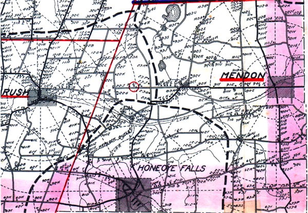
Section of "Clock System" map showing three Commuity
Centers in Monroe County, Rush, Honeoye Falls and Mendon, with radiating
segments and concentric bands. The red circle near the center encloses
a dot locating the William Spatsker Farm that is identified with a
letter "Q."
William (Will) Spatsker and his wife Lillian were the owners of the farm
that has been my home for over forty years. Although the farm is located
in the town of Mendon, it was assigned to the hamlet of Rush in the town
by that name, probably because it was closer. For many years Will Spatsker
had a sign, issued by the company, that read "2-2-Q RUSH," nailed to a
large maple tree in his front yard. The first "2" indicated that his farm
was located slightly north of east of the center, Rush. The second "2"
indicated that it was in the third concentric segment, more than two miles
from Rush. And the letter "Q" pinpointed the map location of the Spatsker
farm on the Mendon Center Road.
Anyone seeking to find the farm merely had to consult the Rural Index
to learn the index number, and then find that number on the accompanying
map that showed the exact location of the farm.
A clock number also proved useful for anyone who became lost while traveling
in an area covered by the Clock Number System. It a person had access
to a Clock System index and map, he only had to look for the first farm
on the road with an index number posted and he could immediately determine
his exact location.
As already mentioned the hamlet of Rush served as the Community Center
for the northwest area of the Town of Mendon. The hamlet of Mendon was
the Center for the northeast and eastern part, and the Village of Honeoye
Falls for the southern part.
I have not been able to determine how extensive an area in New York State,
or in the rest of the country, was covered by the Clock Number System.
However, I know that it was available in all the towns of Monroe County
and in many other counties in the state.
The publishers of the Clock System Rural Index claimed that "This official
numbering of farms is the greatest public improvement and the most useful
service to farmers since the rural delivery of mail."
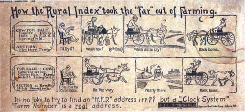
Illustration that appeared on the front cover of the Rural Index
directory of farms in Monroe County
However, an article in the September 6, 1971, Rochester Democrat
& Chronicle stated that the "Clock - System" was not much of a success
and did not last more than a few years. In my interviews with older residents
of the Town of Mendon, I have found only several who can recall seeing
the location sign attached to a tree in front yard of their family home.
Sources of information
Clock System Index & Map, Rochester Democrat & Chronicle
|